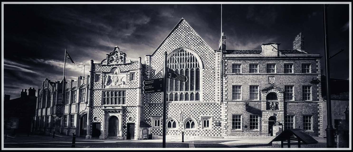
A forgotten figure in Lynn’s Civil War story
The siege of King’s Lynn in 1643 is usually remembered through blockade, bombardment, divided loyalties and surrender. Yet one of the most important figures in the town’s Civil War history was neither a governor nor a famous general. He was Richard Clampe, a physician, mathematician and military engineer whose work helped turn Lynn into what may have been the strongest fortress in East Anglia.
That matters because the Civil Wars were not fought only in open battle. They were also wars of trenches, batteries, bastions, ditches and carefully planned defensive lines. Towns that could be fortified properly became strongpoints, depots and supply centres. King’s Lynn was one of those places, and Clampe was central to its transformation.
A physician with mathematical skill
Richard Clampe was probably born about 1617, although his birthplace remains uncertain. By the 1630s he was certainly living in King’s Lynn. He became a freeman of the town in 1639 or 1640 and was remembered as a physician, doctor and a man learned in mathematics and science.
Those details are more important than they may first seem. In the seventeenth century, military engineering required measurement, geometry, surveying and draughtsmanship. Fortification was technical work. Clampe seems to have brought precisely those gifts into Parliament’s service. There is no strong sign that he had first made his name as a professional soldier. Instead, he appears to have been one of those educated practical men whose knowledge became militarily useful when civil war broke out.
First military work: Earith and the fenland frontier
Clampe first emerges clearly as an engineer in 1643, when Parliament was trying to secure eastern England against Royalist threats. At Earith in Cambridgeshire, a key crossing point near the Isle of Ely, he helped construct a major defensive work usually known as Earith Bulwark.
This was not a crude bank thrown up in haste. It was a substantial bastioned fortification, carefully planned and strategically placed. Its design showed the influence of Dutch fortification methods, which is not surprising in a fenland region already familiar with Dutch expertise in drainage and embankment. The same concern with controlled lines, strong angles and defence in depth would later appear in the works at King’s Lynn.
Why King’s Lynn mattered
To understand why Parliament invested so much effort in Lynn after 1643, one has to remember the town’s geographical value. Its medieval commercial peak had long passed, but it remained an important port linked to coastal trade, inland waterways and regional transport routes. From King’s Lynn, goods could move by water deep into the eastern counties and beyond. In wartime that made the town far more than a provincial settlement.
Lynn was valuable as a logistical centre. Raw materials, imported goods and munitions could pass through its harbour and then be redistributed inland. Supplies for Parliament’s eastern war effort moved through the town, and the waterways gave it unusual strategic usefulness. Once Parliament regained control of Lynn, it had every reason to make sure the place could not easily be lost again.
The town declares for the King
In July 1643 Parliament had already ordered Lynn’s defences to be strengthened, which shows that unease about the town was already present. Events then moved quickly. In August, King’s Lynn declared for the King, becoming the only openly Royalist town in East Anglia. Sir Hamon L’Estrange was made governor.
The Royalist position, however, was precarious from the start. Parliament moved swiftly. The Earl of Manchester’s army besieged the town by land, while the Earl of Warwick’s fleet blockaded it from the sea. Without effective outside relief, Lynn was placed under severe pressure and surrendered on 15 September 1643.
Rebuilding Lynn for war
The surrender did not end the town’s military importance. In one sense it increased it. Once Lynn had been retaken, Parliament did not merely occupy it. It strengthened, redesigned and enlarged its defences. Under Colonel Valentine Walton, Cromwell’s brother-in-law and the town’s governor after the siege, Lynn was systematically refortified.
The evidence points strongly to Richard Clampe as the engineer behind this transformation. His surviving plan deals particularly with the southern sector, but the wider pattern suggests a coherent scheme for the whole vulnerable side of the town. On the east, older lines were reinforced by new bastions. To the north, the area beyond the Gaywood River known as the Loke was enclosed by fresh defensive works. To the south, a new fort was built before the South Gate, with additional lines running towards the Ouse and along the south bank of the Nar.
This was no piecemeal patching. It was the creation of a modern bastioned enceinte around the exposed landward sides of Lynn.
The shape of the new fortifications
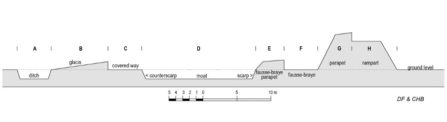
What made these works remarkable was their sophistication. Clampe’s southern design followed advanced Continental, especially Dutch, principles of defence in depth. Instead of a single bank and ditch, the system included a fausse-braye at the foot of the main rampart, then a moat, covered way, glacis and outer ditch.
That layered arrangement was meant to keep enemy artillery at a distance, expose attackers as they advanced, and give defenders multiple advantages in fire and movement. The southern defences were broad and imposing. The whole profile has been calculated at about 56 metres across, and the moat shown in the design measured well over 16 metres wide. This was serious fortress engineering, not improvised emergency digging.
Archaeology and the North Lynn evidence
Recent archaeological work has made Clampe’s achievement clearer. Excavation in North Lynn has helped show that the fortifications were not merely ideal plans on paper. The excavated cuts for the fausse-braye and main rampart matched the drawn evidence closely, which strongly suggests that Clampe’s design was actually built on the ground.
In one section, the moat proved even larger than expected, around 20 metres wide. That is a striking figure when compared with the average widths of many other Civil War defensive ditches. Archaeologists also found wooden posts and a cross-piece at the outer base of the rampart, hinting that some of the earthwork may have been built around a timber framework, with layered clay and turf above it. That offers a rare glimpse of how such defences may physically have been constructed.
The importance of this archaeology is considerable. It does not merely illustrate the written evidence. It strengthens the case that King’s Lynn possessed fortifications of exceptional scale and ambition by the standards of the British Civil Wars.
One of the strongest fortresses in East Anglia
Taken together, the plans, later maps and archaeological findings suggest that post-siege King’s Lynn became one of the strongest fortified places in East Anglia, and perhaps one of the more impressive Civil War fortress works anywhere in the British Isles outside a small number of major centres.
That judgment is not based on rhetoric alone. It rests on the size of the works, the sophistication of their design and the importance of the town as a supply base. Parliament had good reason to invest in Lynn. It was not simply a place to hold. It was a place through which war material moved, a port whose security affected campaigns far beyond west Norfolk.
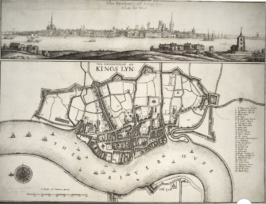
Hollar, maps and the visual record
One of the most useful visual sources for understanding Civil War Lynn is Wenceslaus Hollar’s Groundplat of Kings Lyn. It has often been treated too loosely as if it showed the town at the moment of siege in 1643. In reality, it is better understood as representing the town after the main programme of refortification had been completed, probably around 1645.
Read that way, Hollar’s view becomes an important witness to the finished defensive landscape: not merely medieval walls and gates, but a redesigned fortress town with bastions and modern earthworks.
A fortress that was scarcely tested
Curiously, the great refortification of Lynn was never tried by a full-scale siege after its completion. There was renewed Royalist plotting in late 1644, including Roger L’Estrange’s failed attempt to recover the town, but the scheme collapsed. It may well be that the strength of the works themselves helped discourage serious attack.
The defences endured longer than one might expect. Even in the early eighteenth century, Daniel Defoe commented on the strength of the fortifications. In time, however, their military value faded. Once no longer needed as defences, they became useful sources of clay for brickmaking. Later maps show industrial use encroaching upon them, and excavations have confirmed evidence of brick production in former bastion areas. In that sense, the fortress was gradually consumed by the later town.
Clampe beyond King’s Lynn
Clampe’s importance does not end with Lynn. In 1645 he was employed by the town to survey land affected by the new defences, and by the end of that year he was serving as an engineer, indeed as “chief Engineer”, with the forces besieging Newark. His plan of the siege of Newark became one of the best-known Civil War siege plans to survive.
That wider career matters. It shows that Clampe was not merely a local enthusiast who happened to draw one interesting plan. He was recognised as an engineer of real ability whose work extended into one of the major siege operations of the war.
His later life
After the fighting, Clampe returned to medicine and also served on King’s Lynn’s Common Council. Like many men who were useful in wartime, he seems not to have found the peace especially rewarding. He complained of unpaid arrears and sought compensation for his services.
He was still serving the town in another capacity during the plague outbreak of 1666, when he was paid for attending the infected poor. He died in 1696 at the age of seventy-nine and was buried in St Margaret’s Church, now King’s Lynn Minster. His tomb described him as a man learned in mathematics and science. Sadly, the memorial did not survive the later rebuilding that followed the great storm damage of 1741.
Why Richard Clampe deserves remembering
Richard Clampe deserves a much more prominent place in the history of King’s Lynn. He was not a grand political figure, but he was one of the men who physically altered the town in one of the most dangerous episodes of its history. He helps us see the Civil War not only as a conflict of armies and loyalties, but as a conflict of engineers, surveyors, earthworks and supply routes.
The most revealing point of all is this: Parliament did not simply retake King’s Lynn in 1643. It rebuilt the town for war. Richard Clampe was the man who gave much of that rebuilding its form. Without him, the Civil War landscape of Lynn would have looked very different indeed.
© James Rye 2026
Book a Guided Tour with a Trained and Qualified King’s Lynn Guide Through Historic Lynn
There is a model of Clampe’s defences in the Fred Hall Room, Floor Two, Marriott’s Warehouse.
References
- British History Online. “Journal of the House of Lords: Volume 9, 1646.” London: House of Lords, 1767–1830. https://www.british-history.ac.uk/lords-jrnl/vol9/pp614-615
- British History Online. “Journal of the House of Lords: Volume 10, 1648–1649.” London: House of Lords, 1767–1830. https://www.british-history.ac.uk/lords-jrnl/vol10/pp3-4
- Flintham, David. “King’s Lynn under siege: how a small field in North Lynn illuminated Civil War fortress engineering.” The Past, April 6, 2023. https://the-past.com/feature/kings-lynn-under-siege-how-a-small-field-in-north-lynn-illuminated-civil-war-fortress-engineering/
- Flintham, David. “Richard Clampe, Fortress Engineer, c.1617–1696.” FORT 46 (2019).
- Harrington, Peter. English Civil War Fortifications 1642–51. Oxford: Osprey Publishing, 2003.
- Holmes, Clive. The Eastern Association in the English Civil War. Cambridge: Cambridge University Press, 1974.
- Kent, Peter. Fortifications of East Anglia. Lavenham: Terrance Dalton, 1988.
- Ketton-Cremer, R. W. Norfolk in the Civil War. London: Faber and Faber, 1969.
- Osborne, Mike. Cromwellian Fortifications in Cambridgeshire. Huntingdon: Cromwell Museum with Cambridgeshire County Council, 1990.
- Osborne, Mike. Defending Norfolk. Stroud: Fonthill Media, 2015.
- Pennington, Richard. A Descriptive Catalogue of the Etched Work of Wenceslaus Hollar 1607–1677. Cambridge: Cambridge University Press, 1982.
- Royal Commission on Historical Monuments (England). Newark-on-Trent: The Civil War Siegeworks. London: Her Majesty’s Stationery Office, 1964.
- Smith, Peter. Petitionary Negotiation in a Community in Conflict: King’s Lynn and West Norfolk c.1575 to 1662. PhD diss., University of East Anglia, 2012.
- Yaxley, Stephen, ed. The Siege of King’s Lynn, 1643. Dereham: Larks Press, 1993.