The road hides the river
Thousands of vehicles pass through Southgates every day. Most drivers notice the medieval South Gate standing awkwardly in the middle of the traffic. Few notice the River Nar flowing quietly beneath nearby bridges. Even fewer realise that this was once one of the busiest industrial districts in King’s Lynn.
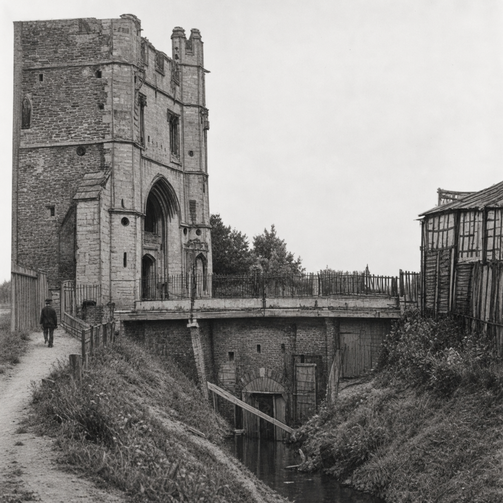
Boston Public Library/DPLA, via Wikimedia Commons.
Where there are now roads, retail parks, and modern buildings, there were once timber yards, shipyards, wharves, railway sidings, gasworks, and fertiliser factories. The River Nar was the thread that connected them all.
It was never the town’s grand river. It was its working river.
The town’s southern frontier
Long before factories appeared, the Nar defined the southern edge of medieval Lynn. The first settlement grew on slightly higher ground between waterways. To the north lay the Millfleet; to the south the Nar. Together they helped protect the town while providing access for trade and fishing.
The South Gate, completed in 1437 by master mason Robert Hertanger, guarded the principal southern entrance. Every traveller arriving from London or Cambridge crossed the Nar before entering the town through its great gateway. Archaeological work has shown that even older defences lie beneath the present structure. Today the gate seems isolated by modern traffic. Originally it stood at the meeting point of road, bridge, ditch, river, and town wall.
A river built for work
The Nar never possessed the impressive quays of the Great Ouse, but it offered something equally valuable: space. Along its banks grew wharves, timber yards, warehouses, and boatyards. Cargo could be unloaded from the Ouse, moved a short distance into the quieter waters of the Nar, and worked on without blocking the busy commercial quays.
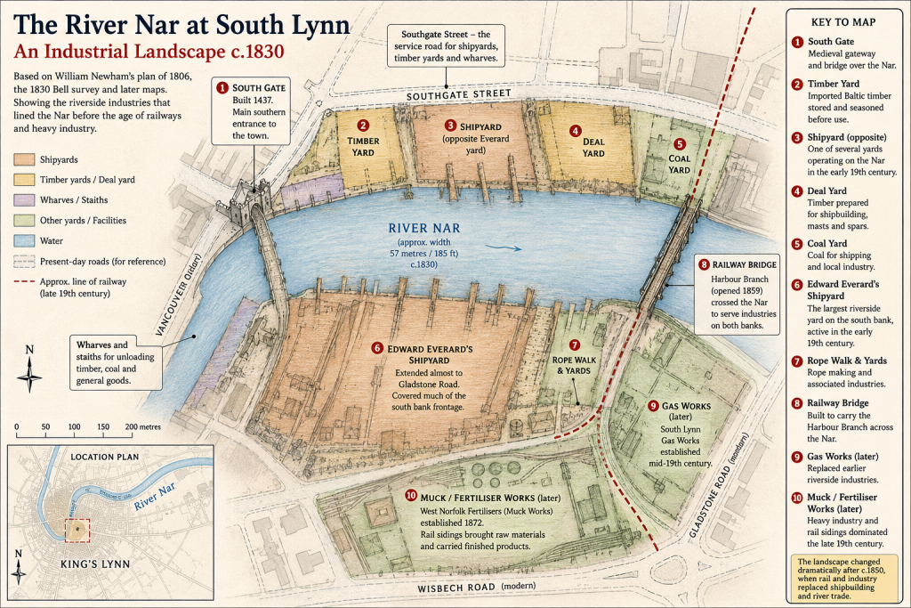
Southgate Street became the service road for this industrial waterfront. The narrow lanes leading towards the river were not designed for shoppers or visitors. They existed to move timber, rope, tools, and cargo between workshops and the water.
By about 1830 maps show an almost continuous stretch of industrial activity between Southgate Street and the river. Timber yards stood beside shipyards, with Edward Everard’s extensive riverside property occupying much of the southern bank towards today’s Gladstone Road.
The Nar itself was then nearly 60 metres wide at this point, very different from the narrower channel we see today.
Where ships were built
The River Nar played an important part in King’s Lynn’s shipbuilding story.
Imported Baltic timber arrived through the port before being stored in riverside yards to season. Nearby shipwrights transformed those great stacks of oak and pine into sea-going vessels.
The names Thomas Melbourne and William Bottomley are well known to students of Lynn’s maritime history, and the Nar formed part of the industrial landscape in which they worked. Merchant families such as the Everards invested heavily in ships, riverside property, and the improvement of navigation, recognising that successful trade depended upon reliable access between inland Norfolk and the port.
Building ships required much more than skilled carpenters. It demanded timber merchants, blacksmiths, sailmakers, rope makers, labourers, and easy access to deep water. South Lynn provided all of them within a remarkably compact area.
Barges instead of wagons
The Nar was valuable for another reason. From 1759 it became a navigable waterway linking King’s Lynn with West Acre. Horse-drawn barges carried coal, grain, and manufactured goods inland before returning with sand, gravel, and agricultural products.
For much of the eighteenth century this was an efficient transport system. A single barge could carry far more than a wagon on Norfolk’s often poor roads.
Merchants like Edward Everard recognised its importance and invested heavily in improving the navigation. The river became an extension of Lynn’s commercial docks, carrying goods between the port and the farming communities of the Nar Valley.
A different kind of industry
The railway changed everything. By the middle of the nineteenth century river navigation was declining. Commercial traffic shifted increasingly to rail, and the character of South Lynn changed once again.
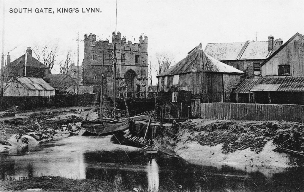
The timber yards and shipbuilding gradually gave way to heavier industry.
A large gasworks rose south of Wisbech Road. West Norfolk Fertilisisers established the works that local people bluntly called the “Muck Works”. Railway sidings crossed the Nar to serve these industries, replacing barges with locomotives as the dominant form of transport.
The river had not lost its usefulness. It had simply acquired a different purpose.
Reading today’s landscape
At first sight, very little survives. The shipyards have disappeared. The gasworks have gone. The fertiliser works have been cleared. The railway has fallen silent. Yet once you know where to look, the old landscape begins to emerge.
Southgate Street still follows the line of the old industrial road. The South Gate still guards the historic entrance to the town. The River Nar still bends quietly towards the Great Ouse. Even modern roads follow routes shaped by centuries of commercial activity.
Historic England believes archaeological remains of the shipyards and other industries may still survive beneath Southgates, hidden below later redevelopment.
Looking beyond the traffic
Southgates is usually seen as somewhere to drive through. For a part of King’s Lynn’s history it was somewhere to work.
Ships were built here. Timber was unloaded here. Barges departed for the Nar Valley. Coal gas was manufactured here. Fertiliser was produced here. Trains crossed here. Hundreds of people earned their living here. The River Nar may never rival the Great Ouse in fame, but it helped create one of the busiest industrial landscapes the town has ever known.
The next time you stop at the traffic lights, imagine the sound of saws instead of engines, the smell of fresh timber instead of exhaust fumes, and barges lying where cars now queue. The road has changed. The river remembers.
© James Rye 2026
Book a Guided Tour with a Trained and Qualified King’s Lynn Guide Through Historic Lynn
References
Borough Council of King’s Lynn and West Norfolk. King’s Lynn: The Friars Conservation Area Character Statement. King’s Lynn: Borough Council of King’s Lynn and West Norfolk. Accessed July 2026. https://www.west-norfolk.gov.uk/download/downloads/id/1913/kings_lynn_the_friars_con_area_leaflet.pdf
Borough Council of King’s Lynn and West Norfolk. Southgates Masterplan. King’s Lynn: Borough Council of King’s Lynn and West Norfolk, 2022. https://www.west-norfolk.gov.uk/download/downloads/id/7392/southgates_masterplan.pdf
Historic England. Revealing the Past of Southgates. https://historicengland.org.uk/whats-new/in-your-area/east-of-england/kings-lynn-research/southgates/
Historic England. Southgates, King’s Lynn, Norfolk: Historic Area Assessment. Research Report 9/2018. https://historicengland.org.uk/research/results/reports/9-2018/
Historic England. The Former South Gate and Southgates Bridge. National Heritage List for England. https://historicengland.org.uk/listing/the-list/list-entry/1003699
Historic England. The South Gate. National Heritage List for England. https://historicengland.org.uk/listing/the-list/list-entry/1195304
Maritime Heritage East. Ship registers and builders’ records. https://www.maritimeheritageeast.org.uk/
Narborough Bone Mill Trust. History of the Bone Mill. https://www.bonemill.org.uk/index.php/sketches/205-history-of-the-bone-mill
Norfolk Heritage Explorer. Site of South Lynn Muck Works (MNF24198).https://www.heritage.norfolk.gov.uk/
Norfolk Rivers Trust. River Nar. https://www.norfolkriverstrust.org/rivers/river-nar