Draining the Fens: The Great Transformation That Still Depends on Pumps
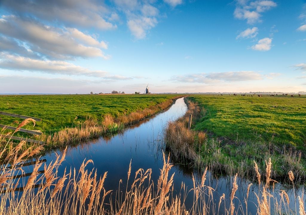
The Fens look solid enough. Roads cross them, trains run through them and enormous fields stretch towards a horizon broken only by church towers, pylons and the occasional pumping station. Yet much of this apparently secure landscape lies below the rivers that flow across it. Some ground is below sea level. Without embankments, sluices and continual pumping, large areas would become waterlogged or flooded.
The drainage of the Fens was not a single seventeenth-century project, nor was it the achievement of one celebrated Dutch engineer. It was a prolonged transformation extending from Roman and medieval water management through the great drainage schemes of the 1600s, the wind and steam pumps of later centuries, and the electrically powered system of the present day.
It produced some of Britain’s richest agricultural land, but it also destroyed most of England’s greatest lowland wetland. It converted common grazing grounds, fisheries and reed beds into privately owned fields. It caused the peat itself to shrink and disappear, leaving the land ever more dependent upon machinery.
King’s Lynn stood at the seaward end of this vast undertaking. Water removed from much of the central and southern Fens ultimately passed the town on its way to the Wash. Lynn’s merchants therefore had good reason to watch every new channel and sluice. A scheme intended to help inland farmers might alter the current, encourage silting or obstruct the approaches to the port. The drainage of the Fens was never merely a Cambridgeshire story. It was also part of the history of Lynn’s river, harbour and commercial fortunes.
Before the straight drains
The historic Fenland covered much of Cambridgeshire, south Lincolnshire and western Norfolk, with extensions into Suffolk and the former county of Huntingdonshire. It was not one continuous swamp. It contained salt marshes, tidal creeks, wet woodland, reed beds, seasonally flooded grassland and shallow lakes known as meres.
Nearer the Wash, repeated tidal flooding deposited marine silt. Further inland, partially decayed vegetation accumulated in waterlogged conditions and formed deep peat. Settlements developed on islands, ridges and firmer patches of ground. Ely, March, Ramsey, Thorney and Whittlesey were all shaped by their position within this watery country. Wisbech, Spalding, Boston and King’s Lynn stood near navigable rivers leading into the Wash.
Water separated communities, but it also connected them. Boats could be more reliable than roads, particularly during winter. Fish, peat, reeds, agricultural produce and passengers travelled along rivers and artificial waterways.
The old Fens were certainly difficult places in which to live. Floods damaged homes and grazing land, while the fever known as ague was common. Yet the landscape was not the worthless waste later described by some drainage promoters.
Fenland families grazed cattle and horses on summer pasture, dug peat for fuel, cut reed and sedge, gathered rushes, trapped wildfowl and caught eels and freshwater fish. Willow and osier supplied material for baskets, fencing and fish traps. Seasonal variations in water level were not simply natural hazards. They formed part of a working economy.
Much of the land was used in common, although common rights were usually regulated. A particular house or tenancy might carry the right to graze a specified number of animals, cut a quantity of turf or harvest sedge from a defined area. Meadows were sometimes divided into narrow strips called doles. Local customs governed when animals could be turned out and when hay or reeds could be cut.
When seventeenth-century improvers called this country unproductive, they were making a political argument. If land could be described as waste, it became easier to justify transferring it to investors who promised to drain and cultivate it.
Drainage before Vermuyden
Human beings had been altering Fenland watercourses long before the famous works of the 1600s. The Romans built roads, embankments and artificial waterways across parts of the region. The Fen Causeway crossed the low country between the Peterborough area and Denver, while the Car Dyke ran for many miles between the Nene and the Witham.
The exact purpose of the Car Dyke remains disputed. It was used as a waterway and may also have assisted with local drainage and water control. Roman settlement expanded on some of the silt soils during the second century, although parts were later abandoned as flooding increased.
Medieval drainage was more localised. The monasteries of Ely, Ramsey, Thorney, Crowland and Peterborough controlled extensive estates and maintained banks, causeways, drains and lodes. A lode was an artificial or improved watercourse used for navigation and sometimes drainage. Medieval landowners reclaimed smaller areas for grazing or meadow and negotiated with their neighbours over the maintenance of banks.
The difference between these works and the later Bedford schemes was principally one of scale. A medieval bank protected a parish, manor or estate. A seventeenth-century drainage undertaking sought to reorganise an entire region.
Even the smaller schemes caused disputes. An embankment that protected one village might force floodwater towards another. Deepening a channel could affect a fishery. A drain designed to empty a field might interfere with navigation. Water could be moved, but it could not simply be made to vanish.
The investors arrive
Large-scale drainage attracted growing interest during the late sixteenth and early seventeenth centuries. Agricultural prices were rising, landowners wanted higher rents, and the Crown hoped to create new taxable estates. Writers and projectors praised agricultural improvement and condemned land that was not being cultivated intensively.
The work required more capital than most individual landowners possessed. An undertaker therefore agreed to organise and finance the drainage. Those who supplied the money were called adventurers because they adventured, or risked, their capital.
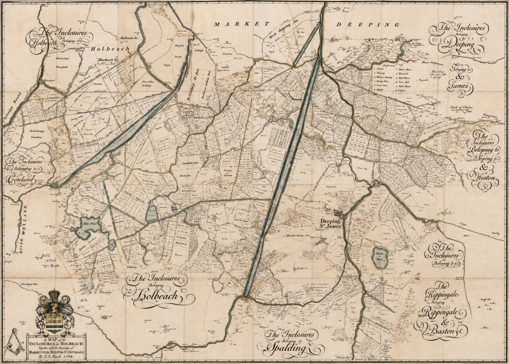
In much of England, enclosure mainly reorganised open arable fields and common pasture. In the Fens it was more tightly linked to water management. A tract of wet common land could not easily be converted into privately farmed fields until it had been drained. Conversely, drainage authorities found it easier to organise channels, rates and maintenance when the land had been divided among identifiable owners.
Their reward was usually land rather than cash. Once the project had been declared successful, the adventurers received part of the supposedly improved territory. This arrangement ensured that drainage and the redistribution of property proceeded together.
Commissions of Sewers supplied part of the legal machinery. Here, the word sewer meant a watercourse or drainage channel, not an underground pipe carrying household waste. Commissioners inspected drains and banks, ordered repairs and levied rates upon landowners judged to benefit from the work.
Arguments arose over the definition of improvement. Ground that served perfectly well as seasonal grazing could be condemned as undrained by someone wanting to grow grain. A channel valuable for fishing or transport might be judged inefficient by an engineer concerned solely with removing water.
Cornelius Vermuyden and an early warning
Cornelius Vermuyden was born in Zeeland around 1590 and came to England during the reign of James I. His first major English drainage undertaking began at Hatfield Chase, near Doncaster, in 1626.
Rivers were diverted and embanked, while Dutch and Flemish workers were brought into the district. Some land was improved, but the scheme caused flooding elsewhere and damaged fisheries, navigation and common rights. Local opposition led to sabotage, litigation and prolonged unrest.
Hatfield Chase exposed the central difficulty of drainage. Engineering works redistributed water and risk. Protecting one estate could endanger another. Draining a marsh could destroy a fishery. Blocking an old channel might harm boatmen and traders.
Vermuyden was an accomplished engineer and promoter, but his reputation later grew beyond the surviving evidence. He became the convenient hero of a story in which one Dutchman arrived and drained the Fens. The real undertaking involved many engineers, surveyors, commissioners, labourers, investors and local landowners.
The Earl of Bedford’s great undertaking
The most famous scheme began in 1630 and 1631, when Francis Russell, fourth Earl of Bedford, headed a group of adventurers seeking to drain the region later known as the Great Level or Bedford Level. Bedford owned substantial estates around Thorney and stood to profit from successful reclamation.
The adventurers were to receive 95,000 acres. Twelve thousand acres were intended for the Crown, while other land would provide revenue for maintaining the drainage works.
The principal new channel ran in a remarkably straight line from Earith to Salters Lode. Originally called the Bedford River, it later became the Old Bedford River. It shortened the route by which water from the Great Ouse could travel towards the tidal river leading through King’s Lynn to the Wash.
Other works included the Forty Foot Drain, together with new embankments and subsidiary channels. In 1637 the undertaking was declared complete. Charles I overturned that decision and assumed control in 1638, anticipating both revenue and a large royal estate. He even considered creating a settlement or palace called Charlemont at Manea.
The Civil War interrupted these plans. Banks were damaged, drainage works neglected and some areas flooded deliberately to hinder military movement. The Isle of Ely and its surrounding waterways formed a natural defensive zone.
Vermuyden’s role in the first Bedford undertaking is not as clear as older histories suggested. The historian Margaret Albright Knittl found no firm evidence that he directed the main works between 1631 and 1637. The initial design appears to have owed much to plans favoured by local Commissioners of Sewers.
Vermuyden certainly advised the Crown after 1638 and played an important part when drainage resumed under William Russell, fifth Earl of Bedford, after 1649. He belongs in the story, but not as its solitary architect.
The Hundred Foot River and the Ouse Washes
Following the execution of Charles I, the Commonwealth government revived the undertaking. An Act passed in May 1649 confirmed the grant of 95,000 acres to Bedford and his associates and gave the adventurers extensive powers to build banks, sluices and channels.
The renewed scheme included a second great channel running roughly parallel with the Old Bedford. This became the New Bedford River, more commonly known as the Hundred Foot River.
The long strip between the Old and New Bedford rivers formed the Ouse Washes. The washes were not a marshy remnant accidentally left behind by unsuccessful engineers. They were an integral part of the design.
During periods of high river flow, excess water could be admitted between the embanked rivers and stored temporarily. This prevented the whole volume from being forced immediately down the lower Great Ouse towards Denver, King’s Lynn and the Wash. The Ouse Washes therefore acted as a controlled flood reservoir.
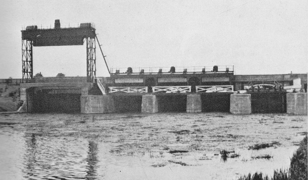
The New Bedford River was completed during the early 1650s. Denver Sluice regulated the meeting of the inland and tidal systems, while the Sixteen Foot, Twenty Foot and Forty Foot drains carried water through the interior.
The works were declared complete in 1652 or 1653. This did not mean that the Fens had been made permanently dry. It meant only that the agreed channels, banks and sluices had been constructed.
The people who fought back
Opposition to drainage was widespread, organised, and sometimes violent. It was not simply the reaction of ignorant villagers frightened by unfamiliar machinery.
Fenlanders broke banks, blocked drains, damaged sluices, obstructed surveyors and drove animals back onto land granted to the adventurers. At Wicken in 1637 and 1638, newly constructed banks were pulled down. Officials attempting to arrest alleged rioters met armed resistance and received little assistance from local officers.
Different groups had different grievances. Fishermen feared the disappearance of meres and shallow waters. Wildfowlers depended upon reed beds. Smallholders needed common grazing, turf and sedge. Boatmen could lose navigable channels. Tenants feared that drainage would increase rents.
The protestors are now popularly called the Fen Tigers. There is ample evidence of local resistance and sabotage, but much less evidence for a single secret organisation operating across the whole Fenland under that name.
The Fen Tigers are best understood as a later symbol encompassing numerous local struggles. The inhabitants of Wicken, Soham or elsewhere usually defended particular commons, fisheries or customary rights. They did not necessarily belong to a unified regional movement.
Nor did the conflict divide neatly between Royalists and Parliamentarians. Some of the leading drainage investors supported Parliament. The Commonwealth government pursued drainage just as firmly as Charles I had done. The dividing line usually concerned land and livelihood rather than national political allegiance.
The land starts to disappear
The seventeenth-century system relied heavily upon gravity. Water was expected to run from fields into drains, from drains into rivers and from rivers towards the Wash when tidal conditions permitted.
For a time, this worked. Then the peat began to shrink.
Wet peat contains an enormous amount of water. When drained, it contracts. Exposure to air also causes the organic material to oxidise, releasing carbon and gradually consuming the soil. Dry peat may be blown away during strong winds in what Fenland people called fen blows. Ploughing hastens the loss.
The rivers, held between embankments, did not necessarily sink with the surrounding land. Fields that had once drained naturally became lower than the waterways intended to receive their water.
This was the fundamental paradox of Fen drainage. The more effectively the peat was drained, the more the land sank. Lower fields required deeper drains and more pumping. Further drainage produced still more shrinkage.
The engineers had not conquered the water once and for all. They had created a landscape that would require increasing amounts of mechanical power simply to remain cultivable.
From windmills to steam engines
Wind-powered drainage mills began to spread across the peat Fens during the later seventeenth century. Their sails drove scoop wheels that lifted water from low field drains into higher channels.
Hundreds eventually stood across the Fenland. They did not replace the great drainage rivers. They enabled smaller districts to discharge into them. Where the difference in level was substantial, water might have to be raised in several stages.
Drainage and enclosure proceeded together. Commons were surveyed, divided and allotted to private owners. Straight drains and droves created the long rectangular fields still characteristic of much of the region.
Steam power brought another transformation during the nineteenth century. Beam engines driving scoop wheels could operate when required rather than waiting for suitable winds. More reliable pumping encouraged the conversion of wet pasture to arable fields and the drainage of surviving lakes.
Whittlesey Mere, once the largest lowland lake in England, was drained during the early 1850s. A rich fishery and wildfowling ground disappeared. The exposed peat began shrinking almost immediately.
The post that seems to grow
The most striking evidence of Fenland subsidence stands at Holme Fen.
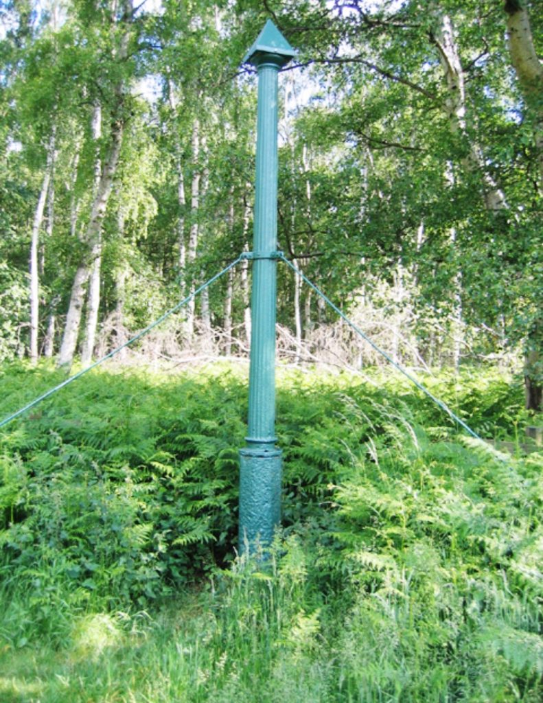
In 1848, before Whittlesey Mere was drained, the engineer John Lawrence drove a timber post through approximately 22 feet of peat until it reached the clay beneath. The top was cut level with the ground. An iron column was later installed as a more permanent marker.
As the peat contracted and wasted away, an increasing length of the column became visible. The post had not risen. The land had fallen around it.
Several metres now stand above the surface. Holme Fen lies about 2.75 metres below sea level and is generally identified as the lowest natural land point in Britain. The post makes the long-term consequence of drainage visible in a way that no set of statistics can equal.
King’s Lynn at the outlet
King’s Lynn occupied a pivotal position because so much Fenland water ultimately had to pass the town before reaching the Wash.
The interests of inland drainage promoters and Lynn’s merchants did not always coincide. Farmers and adventurers wanted water removed from the fields as quickly as possible. Lynn’s merchants wanted a deep and navigable approach to the harbour.
A strong outgoing current could scour silt from the river and assist shipping. A badly designed sluice or diversion, however, might reduce that flow or change where sediment was deposited. Engineering intended to improve farmland many miles inland could therefore affect ships entering Lynn’s port.
The Old and New Bedford rivers altered the route and timing of water entering the lower Great Ouse. Denver Sluice controlled its movement into the tidal river. Every change at Denver had potential consequences downstream.
During the eighteenth and early nineteenth centuries, attention focused upon the twisting course of the Great Ouse south of Lynn. The Eau Brink Cut, completed in 1821, removed a large bend from the river. John Rennie and Thomas Telford were involved in the later stages of the project.
The cut was intended to improve both drainage and navigation by shortening the river’s course. Its initial width proved inadequate, and further work became necessary. The long controversy surrounding Eau Brink showed how difficult it was to predict the behaviour of tide, current and silt.
Lynn’s Corporation and commercial community could not simply oppose drainage, because a well-scoured river was advantageous to the port. Nor could they accept every inland scheme without question. The consequences might not become apparent until channels had silted or the tidal flow had altered.
St Germans and the water passing Lynn
The nineteenth-century Middle Level Main Drain created a more direct outlet from the central Fens to the tidal Great Ouse near Wiggenhall St Germans.
As the peat continued to sink, gravity drainage became ineffective. The first St Germans pumping station opened in 1934, lifting water from the Middle Level into the tidal river. From there it passed northwards towards King’s Lynn and the Wash.
The modern replacement station entered service in 2010. It is the largest land-drainage pumping station in Britain and is capable of discharging about 100 cubic metres of water each second. It operates alongside dozens of smaller stations and hundreds of kilometres of drains and embankments.
Its scale is difficult to appreciate from the quiet landscape surrounding it. Water collected across a large part of the central Fens converges upon St Germans, is raised mechanically into the tidal Great Ouse and then flows past Lynn.
During periods of exceptionally heavy rainfall, the volume is immense. Between October and December 2023, St Germans pumped more than 80,000 megalitres of water. In February 2024 alone, the station pumped almost 58,500 megalitres.
Lynn therefore remains connected to rainfall and pumping decisions far inland. Water falling around March, Chatteris, Ramsey or Whittlesey can eventually pass the town. The drainage network is regional, but Lynn stands close to its final outlet.
Floods and the Relief Channel
Drainage never abolished flooding. Severe floods in March 1947 followed deep snow, heavy rain and rapid thawing. The North Sea flood of January 1953 demonstrated the danger from the opposite direction, when a storm surge overwhelmed coastal defences.
Post-war engineers strengthened embankments, modernised pumping stations and constructed new flood channels. The Great Ouse Cut-off Channel intercepted water from the Rivers Lark, Little Ouse and Wissey before it could enter the lowest Fenland districts.
The Relief Channel provided another route from Denver towards the tidal river near King’s Lynn. Completed as part of the post-war programme, it brought the machinery of Fenland drainage still closer to the town.
The modern system does more than remove water. In dry summers, water must sometimes be retained or brought into the network for crops, navigation and wildlife. The task is therefore to manage alternating excess and shortage.
Responsibility is divided among the Environment Agency, Internal Drainage Boards, the Middle Level Commissioners, landowners and local authorities. Water may pass from a field ditch into an Internal Drainage Board channel, through a pumping station into a main river and finally towards the Wash.
What was gained, and what was lost
The agricultural achievement is formidable. The Fens contain a large proportion of England’s highest-quality farmland. Their soils support wheat, barley, sugar beet, potatoes, carrots, onions, brassicas, salad crops and flowers.
The region also sustains food-processing businesses, agricultural engineering, transport and substantial employment. Settlements, roads, railways and utilities have grown upon the assumption that the drainage system will continue to function.
Yet most of the old freshwater Fenland has vanished. Meres, reed beds, wet woodland and species-rich meadows survive only in fragments. Wicken Fen, Woodwalton Fen and Holme Fen preserve something of the former environment, but even these places require careful water management.
The surviving wetland reserves can now stand above the neighbouring farmland because the cultivated peat has sunk. Water leaks from the reserves into lower agricultural drains. Preserving a wet fen in modern Fenland may therefore require banks, sluices and pumps.
The continuing loss of peat presents a threat to agriculture itself. The rich organic soil is finite. As it oxidises, the land sinks and carbon is released. Once the peat has disappeared, less fertile material may be exposed.
Drainage also threatens archaeology. Waterlogged peat can preserve timber, leather, seeds and other organic remains that normally decay. Lowering the water table exposes them to air. Sites such as Flag Fen and Must Farm demonstrate the extraordinary preservation possible in Fenland deposits, but unknown sites may be deteriorating before they are discovered.
Six persistent myths
The first myth is that Vermuyden arrived from the Netherlands and drained the Fens. Drainage had been taking place for centuries. Vermuyden played an important role, especially after 1638 and during the renewed undertaking of the 1650s, but his direction of the first Bedford scheme is unproven.
The second is that the undrained Fens were worthless swamps. They supported fishing, grazing, wildfowling, peat digging, reed cutting and water transport. Drainage replaced one productive economy with another.
A third myth presents opposition as an irrational rejection of progress. Many commoners understood that drainage would increase the value of the land. Their complaint was that the increased value would pass largely to adventurers and landowners while they lost grazing, fuel and fisheries.
The Fen Tigers provide a fourth misconception. Fenlanders certainly sabotaged banks and drains, but the evidence for one organised regional movement bearing that name is weak. The term is better understood as a later label for many local campaigns.
The fifth myth is that the seventeenth-century drainage solved the problem. Peat shrinkage soon undermined gravity drainage, leading to the use of windmills, steam engines, diesel pumps and electric stations.
Finally, not every straight channel was dug by Vermuyden. The landscape contains Roman waterways, medieval lodes, Bedford Level rivers, parliamentary drains, nineteenth-century cuts and modern flood channels. The Fens are not the product of one plan but of centuries of alteration.
A machine the size of a landscape
The drainage of the Fens has never been finished. The Roman and medieval works were followed by the Bedford rivers, the Ouse Washes, wind-powered mills and steam pumping. Diesel engines and electric motors took over, while modern authorities added relief channels and remotely controlled sluices.
King’s Lynn remains at the lower end of this system. Denver Sluice, Eau Brink Cut, St Germans pumping station and the Relief Channel all influence the movement of water towards the town.
The scale of present dependence is sobering. More than 600,000 people live within the wider Fenland covered by the government’s Fens 2100+ programme. Current assessments warn that a substantial proportion of flood-management assets will reach the end of their expected working lives within the coming decades.
The modern Fens are neither entirely natural nor permanently reclaimed. They form a machine spread across hundreds of square miles, operated through drains, banks, pumps and sluices.
Its agricultural success is undeniable. So is the price. Most of a vast wetland was lost, common rights were extinguished and deep peat began to disappear. The drainage of the Fens was not a victory completed by Vermuyden in the seventeenth century. It is an undertaking that must be repeated every day.
© James Rye 2026
Book a Walk with a Trained and Qualified King’s Lynn Guide
References
- Ash, Eric H. The Draining of the Fens: Projectors, Popular Politics, and State Building in Early Modern England. Baltimore: Johns Hopkins University Press, 2017.
- Darby, H. C. The Changing Fenland. Cambridge: Cambridge University Press, 1983.
- Darby, H. C. The Draining of the Fens. 2nd ed. Cambridge: Cambridge University Press, 1956.
- Dugdale, William. The History of Imbanking and Drayning of Divers Fenns and Marshes. London: Alice Warren, 1662.
- Environment Agency. Fens 2100+: Great Ouse Flood Risk Baseline. Bristol: Environment Agency, 2025. https://assets.publishing.service.gov.uk/media/69caaaf72c5db1b1db67e9d0/Fens_2100%2B_Great_Ouse_-_Flood_Risk_Baseline.pdf.
- Environment Agency. Fens 2100+: Summary Baseline Report. Bristol: Environment Agency, 2026. https://www.gov.uk/government/publications/fens-2100/fens-2100-summary-baseline-report.
- Great Fen Project. “A Brief History of the Great Fen.” Wildlife Trust for Bedfordshire, Cambridgeshire and Northamptonshire. https://www.greatfen.org.uk/about-great-fen/heritage/brief-history-great-fen.
- Great Fen Project. “Holme Fen Posts.” Wildlife Trust for Bedfordshire, Cambridgeshire and Northamptonshire. https://www.greatfen.org.uk/about-great-fen/heritage/holme-fen-posts.
- Knittl, Margaret Albright. “The Design for the Initial Drainage of the Great Level of the Fens: An Historical Whodunit in Three Parts.” Agricultural History Review 55, no. 1 (2007): 23–50. https://www.bahs.org.uk/AGHR/ARTICLES/55_102Knittl.pdf.
- Lindley, Keith. Fenland Riots and the English Revolution. London: Heinemann Educational Books, 1982.
- Middle Level Commissioners. “History.” Accessed 25 June 2026. https://middlelevel.gov.uk/education/.
- Middle Level Commissioners. Working to Protect Life and Property from Flooding. March: Middle Level Commissioners, 2013. https://middlelevel.gov.uk/wp-content/uploads/2017/08/Middle-Level-Booklet-Oct-2013.pdf.
- Wells, Samuel A. The History of the Drainage of the Great Level of the Fens Called Bedford Level. 2 vols. London: R. Pheney, 1830.