A little over two miles east of historic King’s Lynn stands the broken west wall of a medieval church. There is no village around it, no congregation, and scarcely enough masonry to reveal the building’s original shape.
This is St Michael’s, Mintlyn. Its history reaches from Domesday Book to Margery Kempe, and from Norwich monks to a seventeenth-century curate paid one shilling for each Sunday service.
The church once stood on one of the highest points in the area, overlooking Lynn and the flat marshlands to the west. The ruins , enclosed within an overgrown rectangular churchyard, stand at the corner of an arable field. Just 50m to the south is the track of the dismantled Lynn to Fakenham railway (later Midland and Great Northern).
Mintlyn is not Bawsey
Mintlyn Church is sometimes confused with the larger ruin of St James’s at Bawsey. They are separate buildings, standing about a mile apart.
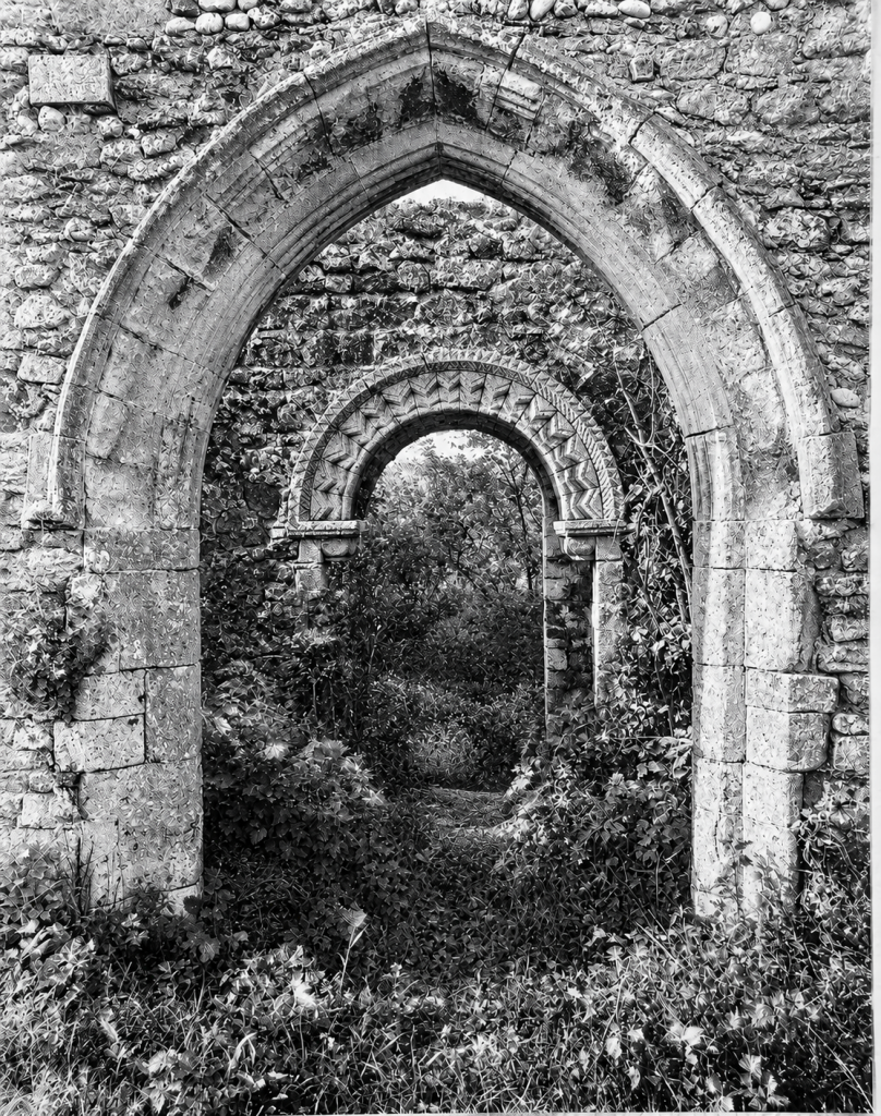
B37/609 copyright Royal Commission on Historical Monuments (England).
St James’s occupies higher ground to the north-east. It is a Grade I listed building containing eleventh-century work, a central tower, and a magnificent Norman arch. Archaeological finds suggest that Bawsey may have developed around an important Anglo-Saxon religious centre.
St Michael’s, at National Grid Reference TF 65711 19258, is Grade II* listed. There is no evidence that it was a Saxon minster. That interpretation belongs to Bawsey.
The settlement of Meltinga
Mintlyn appears in Domesday Book in 1086 as Meltinga. It lay within Freebridge Hundred and had 21 recorded households: 15 freemen and six smallholders. Bishop William of Thetford was the lord and tenant-in-chief.
Domesday’s “households” were not individual inhabitants. The real population, including wives, children, and servants, would have been larger, although its size cannot be calculated reliably.
No church is mentioned. Domesday did not record every English church, so its silence is not conclusive. The earliest surviving architectural evidence at Mintlyn, however, belongs to the twelfth century.
The place-name’s origin is uncertain. Norfolk Heritage Explorer tentatively suggests that it may mean “Myntel’s people”. An older story connected it with a bishop’s mint, but no evidence has been found that coins were struck there.
A small Norman church
St Michael’s was built principally from carstone, the iron-rich brown sandstone found across West Norfolk. Flint, field stones, and limestone dressings were also used.
The church probably consisted of a nave, chancel, and south porch. Part of the west gable remains standing, together with a fragment at the south-east corner. The large west window was inserted during the fifteenth century and once contained cusped tracery.
The Norman south doorway was apparently the church’s most decorative feature. The antiquarian Charles Keyser recorded fragments of a carved semicircular panel, known as a tympanum, above the entrance. John Sell Cotman drew and etched the doorway in about 1817, when much more of it remained visible.
A plain twelfth-century limestone font was removed to the garden at Whitehouse Farmhouse, where it remains separately listed. Other carved fragments were transferred to the museum at King’s Lynn. A medieval coffin lid can still be found close to the former south porch.
A church in Lynn’s orbit
Although St Michael’s served a rural settlement, it had strong connections with Bishop’s Lynn.
Francis Blomefield and Charles Parkin, drawing upon medieval ecclesiastical records, wrote that Bishop Herbert Losinga gave Mintlyn Church to the Norwich monks whom he established at Lynn. Early thirteenth-century charters associated with Bishop John de Grey confirmed the monks’ interests in Lynn, Gaywood, and Mintlyn.
By about 1205, St Michael’s and at least some of its income were connected with the Benedictine priory at Lynn, itself dependent upon Norwich Cathedral Priory. Mintlyn was also closely associated with Gaywood and was taxed with it.
An early sixteenth-century map of the countryside around Middleton and Mintlyn shows roads, woods, marshes, dykes, pastures, and common land. The words “Mintlynge Towne” appear on the plan. “Town” then could mean a rural township rather than an urban community, but the label confirms that Mintlyn remained a recognised settlement.
Margery Kempe’s church in the field
The most vivid possible glimpse of St Michael’s appears in The Book of Margery Kempe.
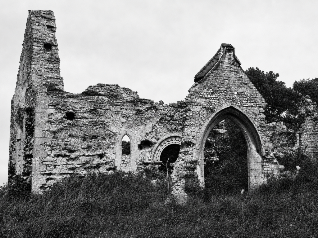
B37/608 copyright Royal Commission on Historical Monuments (England).
Margery was born in Bishop’s Lynn in about 1373. Her book records her visions, pilgrimages, religious disputes, and famously noisy outbursts of devotional crying. Some clergy suspected that she cried to attract attention.
In Chapter 83, two priests decided to test her. They invited her to walk “too myle … to a cherch stod in the feld”. The church stood well away from any house and was dedicated to St Michael the Archangel. The priests took only one or two children, removing the audience before whom Margery usually wept.
Once inside, Margery began crying and sobbing as loudly as she did among the people of Lynn. The priests returned home more convinced that her behaviour was genuine.
Margery’s book does not name Mintlyn. The identification rests upon the dedication, the reported distance from Lynn, and the description of an isolated church standing in a field. Modern scholars generally accept St Michael’s, Mintlyn, as the likely destination.
It remains a strong probability rather than a proven fact. If the identification is correct, St Michael’s served not only its small rural parish but also as a modest destination for pilgrims from Lynn.
Fourteen communicants
Claims that St Michael’s was abandoned during the sixteenth century are contradicted by a surviving church return.
In August 1603, William Dixon was recorded as curate of “Mintlinge”. The parish had 14 communicants, with no recusants or noncommunicants reported. Thomas Thursby, who controlled the cure, allowed Dixon 12 pence for each Sunday service.
Fourteen communicants formed a very small congregation, but the figure did not include every resident. Children and others who did not receive communion fell outside the total. The record nevertheless establishes that St Michael’s still had a curate and regular Sunday worship in 1603.
Later reports describe a building becoming increasingly difficult to maintain. The roof allegedly needed tiling in 1673. By 1679 there was no font, a basin was being used in connection with baptism, and vegetation was invading the structure. Problems with the bell were reported in 1682.
No reliable date has been found for the final service.
Did Thomas Thursby (Thoresby) destroy Mintlyn?
The disappearance of Mintlyn is often attributed to Thomas Thursby, a member of a wealthy King’s Lynn merchant family. The Thursbys acquired land around Gaywood, Mintlyn, Ashwicken, Leziate, and Bawsey. They were accused of enclosing common land, removing tenants, demolishing houses, and turning arable fields into sheep pasture.
The enclosure inquiry of 1517 specifically accused Thomas Thursby of depopulating Holt, a hamlet described as lying within Mintlyn parish. It did not say that he cleared the whole of Mintlyn. (It should also be noted that this Thomas Thursby is not the founder of Thoresby College, but his son.)
Later evidence also argues against complete destruction in 1517. “Mintlynge Towne” appears on an early Tudor map, St Michael’s had 14 communicants in 1603, and a seventeenth-century estate map showed several cottages.
Published accounts disagree about whether that map contained five cottages or approximately ten houses. They also date it either to about 1690 or 1698. Until the original map is examined, “several cottages in the later seventeenth century” is the safest description.
Enclosure probably contributed to Mintlyn’s decline, but no document identifies a single event or individual as the cause. Changes in farming, loss of common rights, estate consolidation, movement towards Lynn, and the cost of maintaining a church for a tiny congregation may all have played a part.
A village which left few marks
Norfolk Heritage Explorer calls Mintlyn a deserted medieval village. Historic England’s investigators were more cautious. Apart from a scatter of medieval pottery, they found no visible settlement earthworks around Mintlyn Farm. Aerial photographs revealed no convincing streets or house platforms.
Centuries of ploughing, forestry, drainage, and estate management may have erased the remains. Even so, no reliable plan of the former village can presently be drawn.
By about 1817, when Cotman recorded its doorway, St Michael’s was already a ruin. In 1848, Samuel Lewis described Mintlyn as a parish of 36 inhabitants and said that the church had been “demolished”. He plainly meant that it had disappeared as a usable building, since the west wall survived.
That wall still stands in the field. The font rests at a nearby farmhouse, pieces of the doorway are preserved in King’s Lynn, and Margery Kempe’s book may contain a record of the church when priests, children, and pilgrims still walked out to it from Bishop’s Lynn.
© James Rye 2026
Book a Walk with a Trained and Qualified King’s Lynn Guide
References
- Bailey, Anne E. “The Problematic Pilgrim: Rethinking Margery’s Pilgrim Identity in The Book of Margery Kempe.” The Chaucer Review 55, no. 2 (2020): 171–196. https://www.jstor.org/stable/10.5325/chaucerrev.55.2.0171
- Batcock, Neil. The Ruined and Disused Churches of Norfolk. East Anglian Archeology Report No 51, 1991.
- Blomefield, Francis, and Charles Parkin. An Essay Towards a Topographical History of the County of Norfolk. Vol. 8. London, 1808. “Mintling.” https://www.british-history.ac.uk/topographical-hist-norfolk/vol8/pp425-439
- Dallas, Paul. “Elite Landscapes in Late Medieval and Early Modern East Anglia.” PhD diss., University of East Anglia, 2014. https://ueaeprints.uea.ac.uk/47936/1/ThesisPDFcopy.pdf
- Fitzwilliam Museum. Cotman, John Sell. Door-Way Mintlyn Church, Norfolk. Etching, c. 1817. https://data.fitzmuseum.cam.ac.uk/id/object/184873
- Historic England. “Church of St James, Bawsey.” National Heritage List for England, List Entry 1077664. https://historicengland.org.uk/listing/the-list/list-entry/1077664
- Historic England. “Remains of St James’ Church and Surrounding Saxon and Medieval Settlement.” National Heritage List for England, List Entry 1019667. https://historicengland.org.uk/listing/the-list/list-entry/1019667
- Historic England. “Ruins of Church of St Michael at TF 657 192.” National Heritage List for England, List Entry 1342379. https://historicengland.org.uk/listing/the-list/list-entry/1342379
- Historic England Research Records. “St Michaels Church, Mintlyn.” Hob UID 356226. https://www.heritagegateway.org.uk/Gateway/Results_Single.aspx?resourceID=19191&uid=356226
- Jessopp, Augustus. “The Condition of the Archdeaconry of Norwich in 1603.” Norfolk Archaeology 10 (1888): 1–49. https://archive.org/details/norfolkarchaeol15socigoog
- Kempe, Margery. The Book of Margery Kempe. Edited by Lynn Staley. Kalamazoo, MI: Medieval Institute Publications, 1996. Book I, chapter 83. https://metseditions.org/read/49xVak9f2YK3hjdKTvyq3HqWgzkGAd9
- Norfolk Heritage Explorer. “St Michael’s Church and Mintlyn Deserted Medieval Village.” NHER 3410. https://www.heritage.norfolk.gov.uk/record-details?MNF3410-St-Michael%27s-Church-and-Mintlyn-deserted-medieval-village=
- Open Domesday. “Mintlyn.” https://opendomesday.org/place/TF6519/mintlyn/
- The National Archives. “Plan Showing Middleton and Mintlyn.” MPI 1/64. https://discovery.nationalarchives.gov.uk/details/r/C4047265