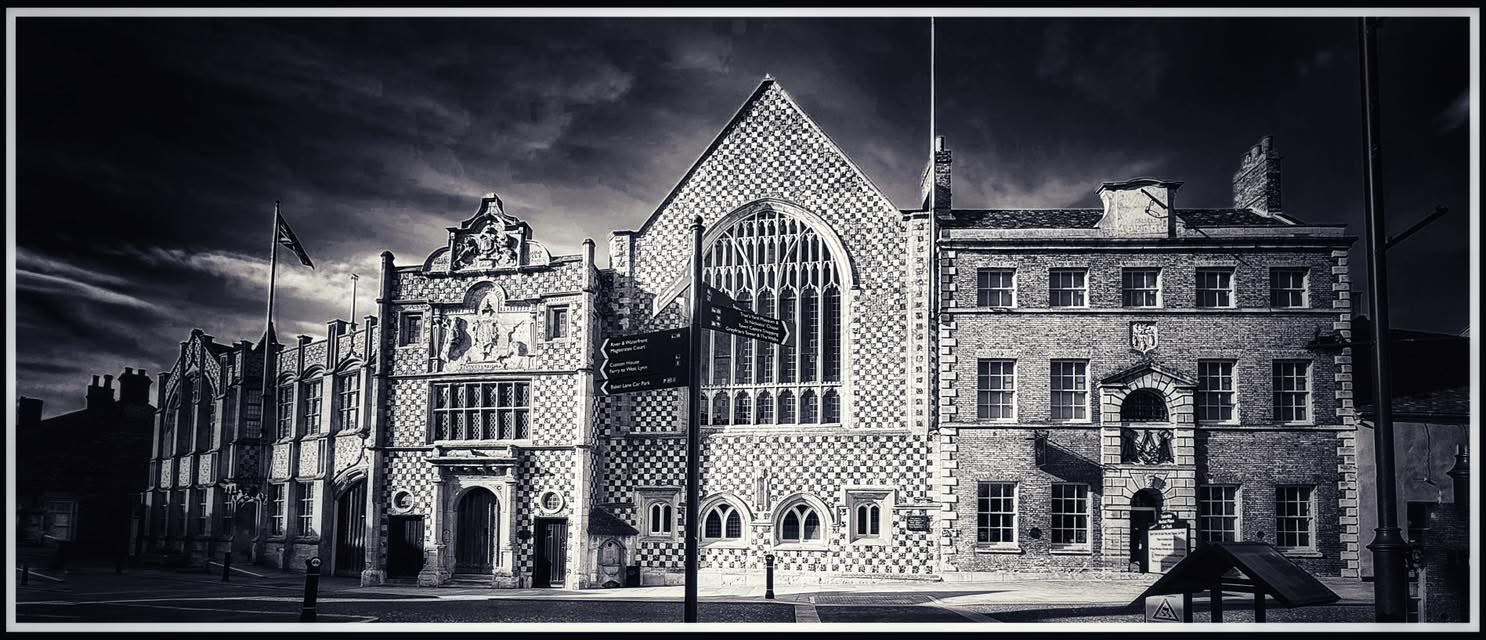
A threat thirty miles up river
On 6 January 1696, Edmund Hooke, mayor of King’s Lynn, appealed to William Russell, Duke of Bedford, about a problem nearly thirty miles upriver. Hooke and his fellow merchants believed that something at Denver was slowly damaging the river on which Lynn’s prosperity depended. Their target was Denver Sluice, built in the early 1650s as part of the enormous scheme to drain the Fens. The dispute was already more than thirty years old. In 1665 Lynn had supported a parliamentary bill proposing the most radical solution possible: remove the sluice altogether. Now the town was preparing to take the argument back to Parliament.
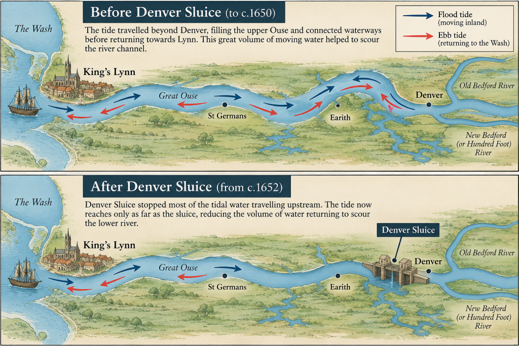
Lynn’s complaint was not simply that Denver made navigation inconvenient. The Corporation believed that the drainage works had interfered with the natural mechanism that kept the Great Ouse deep. Before Denver, the tide travelled much farther inland, filling the Ouse and its connected waterways before returning towards Lynn and the Wash. Lynn argued that this great volume of moving water scoured sand and mud from the channel. Freshwater arriving from inland provided additional flow. Denver prevented much of the tide travelling upstream, while the New Bedford or Hundred Foot River altered the route taken by freshwater. In Lynn’s view, its river was being deprived of scouring water from both directions.
This mattered because Lynn’s harbour extended economically far beyond the quays. The town was the maritime entrance to a network of waterways reaching towards Ely, Cambridge, Huntingdon, St Ives, and Bedford. Ships arriving at Lynn unloaded goods that continued inland by barge, while agricultural produce travelled downstream for shipment from the port. Coal, timber, salt, iron, wine, pitch, and tar were among the commodities moving through this system. A change to the river at Denver could therefore affect merchants at King’s Lynn and customers many miles inland.
The bargain made at Lynn
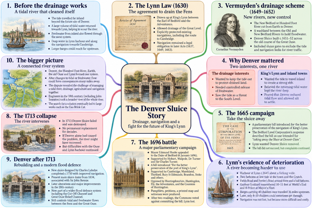
King’s Lynn had been involved in the Fen drainage project from its beginning. In 1630 Francis Russell, 4th Earl of Bedford, and the other investors known as the Adventurers undertook the drainage of the Great Level. Their agreement became known as the Lynn Law because it was concluded at King’s Lynn. Navigation was explicitly recognised. The Adventurers could drain the Fens, but established waterways, including the important navigation towards Cambridge, were to be protected. Similar safeguards appeared in subsequent legislation. Lynn could therefore argue that the preservation of navigation was part of the original bargain under which the transformation of the Fens had been permitted.
After an initial phase of drainage and the interruption of the Civil War, a much larger scheme was undertaken under Cornelius Vermuyden. The New Bedford or Hundred Foot River was cut from Earith towards Denver, with a long area of washland between it and the Old Bedford River to accommodate floodwater. At Denver the engineers faced a basic problem. The Great Ouse below them was tidal. Unless something prevented it, water from the Wash could continue inland and interfere with the drainage of the South Level.
Denver Sluice, constructed around 1651–52, was intended to control that tide. Its gates prevented tidal water travelling freely upstream while allowing freshwater to escape when conditions permitted. Provision was also made for navigation. This is important because the drainage engineers were not simply ignoring the needs of river traffic. The dispute arose because Lynn increasingly believed that allowing boats through a lock was not the same thing as preserving the river itself.
The two sides looked at the same water and saw opposite things. To the Bedford Level interests, an incoming tide was a threat to land they had spent enormous sums trying to drain. To Lynn, that same tidal water performed useful work. It travelled inland, filled miles of waterways, turned, and returned towards the Wash, helping to scour the Ouse as it went. Preventing it from passing Denver might protect the Fens, but Lynn feared that it would weaken the ebb downstream and allow sediment to settle.
Take Denver away
The consequences seemed serious very quickly. By 1665, little more than a decade after the sluice had been constructed, the dispute had reached Parliament. A bill was introduced for the better preservation of the navigation of the port of King’s Lynn. We know how radical its proposed remedy was because the Bedford Level Corporation printed a response describing the bill as one intended for “taking away the Sluce at Denver-Dam”. Lynn wanted the structure removed.
The Bedford Level Corporation had an obvious answer. Denver formed part of an interconnected drainage system. Allowing the tide freely upstream again might provide Lynn with additional scouring water, but it could also return tidal water to the South Level. The argument was therefore more difficult than a struggle between merchants who wanted navigation and engineers who wanted drainage. Both interests depended upon control of the same river, but they wanted it to behave differently.
The sluice survived, but Lynn continued collecting evidence of what it believed had been lost. Some of this survives through later writers and must therefore be treated cautiously, yet the detail is striking. Around 1645 the haven at Lynn was said to have been about a furlong wide. Ships could lie at the southern end of the town and along the western side in around two fathoms of water at low tide. Two deeper anchorages, remembered as Fields or Fieln’s Road and Ferrier’s Road, supposedly retained about three and a half fathoms, roughly twenty-one feet. The tidal current was said to have been powerful enough for ships to require stream cables to hold them securely.
Guybon Goddard, Recorder of Lynn, provided particularly interesting evidence because he had lived through the period when Denver was constructed. He remembered ten or eleven feet of water at low tide at a place in Lynn harbour called World’s End and eight or nine feet at Mayor’s Fleet, associated with the old Mill Fleet system towards the southern part of the town. These were not merely nostalgic claims that everything had once been better. Lynn’s supporters were trying to establish measurable changes in the river.
When smaller barges struggled
The evidence about barges gave the argument an economic edge. Before the drainage works, vessels carrying forty chalders were said to have travelled thirty-six miles up the Ouse, while barges carrying twenty-six to thirty chalders could reach Cambridge. Later accounts claimed that flat-bottomed lighters carrying only eight or ten chalders sometimes struggled with the shallows. A chalder was not a fixed modern measure, so attempting an exact conversion into tonnes would give a misleading impression of precision. The important point was the difference in carrying capacity.
A river did not need to become completely unnavigable before merchants suffered. If cargo that had once travelled in one barge required two, the costs of boats, crews, towing horses, journeys, and handling increased. This may explain an apparent contradiction in the evidence. Modern research indicates that waterborne trade through Lynn actually expanded during the later seventeenth century. That does not necessarily disprove the town’s complaints. More goods could be moving through the system while individual vessels carried smaller loads or encountered increasing difficulty. Lynn did not need to demonstrate that navigation had ceased. Its case was that navigation had been injured despite the promises made when drainage began.
By the 1690s the Corporation’s argument had also become more sophisticated. Denver remained central, but Lynn increasingly treated the Hundred Foot River, the works at Earith, the old Ouse, and the lower river towards Lynn as parts of a single system. Denver restricted tidal water entering from below, while the new channels altered freshwater coming from above. The old Ouse, Lynn believed, was losing the moving water that had previously kept it open.
The mayor takes on the Duke
This was the problem confronting Edmund Hooke when he became mayor in 1695. Rather than going immediately to Parliament, Hooke first attempted negotiation. On 6 January 1696 he appealed to William Russell, Duke of Bedford, governor of the Bedford Level Corporation. The approach was supported by an influential Norfolk group including Sir Henry Hobart of Blickling, Robert Walpole of Houghton, Dr John Turner of Lynn, and Sir Charles Turner. The Robert Walpole involved was the father of the future prime minister, who was still a boy.
When negotiation failed to produce a satisfactory settlement, Sir Charles Turner introduced a bill “For the better preservation of the port of King’s Lynn”. Lynn also recruited allies. Cambridge had an obvious interest because its waterborne connection with the sea ran through Lynn, but support also came from Marshland, Thetford, Bury St Edmunds, Brandon, Stoke, and other communities connected with the eastern river system. The Corporation could now present its campaign as the defence of a regional trading network rather than a private quarrel between Lynn merchants and Fen landowners.
The opposition was equally organised. Petitions came from Huntingdonshire, Huntingdon, Ely, the Adventurers, and others who feared the consequences of interfering with the drainage system. The Countess of Huntingdon became involved, prompting Lynn to print an answer to one of her petitions. Both sides were mobilising political influence, petitions, and printed arguments.
In 1696 Lynn published The Case of the Town and Port of King’s-Lynn in Norfolk, as to their Navigation. It was part of a wider lobbying campaign involving cases and counter-cases, petitions, replies, and evidence. Papers associated with the controversy even include a printed map of the Bedford Level, apparently from about this period. MPs unfamiliar with the Fens could therefore be shown how Lynn, Denver, the Ouse, and the drainage works fitted together.
The parliamentary proceedings went beyond an exchange of pamphlets. The bill received two readings, and counsel and witnesses were heard from both sides. Unfortunately, the names and detailed testimony of those witnesses have not yet been recovered, so we cannot safely attribute the surviving statements about depths and barge capacities directly to evidence given before MPs. What we can say is that Parliament heard a contested case involving navigation, drainage, and the economic consequences of altering the river.
Then came the vote on whether the bill should be committed for detailed consideration.
The motion failed. Lynn had lost.
The Ouse demolishes Denver
Seventeen years later the river provided an unexpected test of Lynn’s argument. In 1713 Denver Sluice failed. The structure Lynn had once asked Parliament to remove was destroyed by water, and no permanent replacement was completed for decades. If Denver alone had been responsible for depriving the lower Ouse of its tidal scour, its disappearance ought to have produced a marked recovery.
It did not. Problems with the Ouse and Lynn harbour continued, although this did not prove that Denver had been harmless. By 1713 the Fenland waterways had been profoundly altered. New channels redirected freshwater, embankments constrained the rivers, drained land was changing, and sediment continued to move through the Wash and lower Ouse. Removing one structure could not recreate the river that had existed before the great drainage works.
During the eighteenth century engineers therefore began to look beyond Denver itself. Thomas Badeslade remained a determined critic of the sluice, but later investigators increasingly treated the lower Ouse as a complete hydraulic system. When John Smeaton examined Lynn harbour in the 1760s, he was unwilling to accept that Denver alone explained its deterioration. The width and shape of the river, the concentration of the current, and the movement of sediment all mattered. This broader understanding eventually contributed to schemes such as the Eau Brink Cut.
Denver after 1713
Denver Sluice did not disappear permanently. After decades without an effective replacement, a new structure designed by Charles Labelye, the engineer of Westminster Bridge, was completed around 1750 and included improved provision for navigation. The present main sluice dates principally from 1834 and is associated with Sir John Rennie, although later alterations have repeatedly modernised the complex. During the twentieth century Denver became part of a much larger system of flood control involving the Cut-Off Channel and Great Ouse Relief Channel. The structures have changed enormously since Vermuyden’s time, but Denver still occupies the same strategic point between the tidal Great Ouse towards King’s Lynn and the controlled waterways of the Fens.
The seventeenth-century argument was therefore never simply about whether a sluice was good or bad. Two enormous economic interests required contradictory things from the same river. The drainage of the Fens depended upon keeping unwanted tidal water out, while the prosperity of King’s Lynn depended upon maintaining enough moving water to keep the Ouse navigable. Lynn’s merchants understood that their harbour did not end at the quays. What happened at Denver or Earith could eventually be felt beside the warehouses of King’s Lynn.
In 1665 Lynn tried to have Denver Sluice removed. Thirty years later Edmund Hooke and his allies returned to the fight, recruiting other towns, confronting powerful landed interests, printing their case, producing witnesses, and appealing to Parliament. Parliament rejected them.
Then, in 1713, the Great Ouse demolished the sluice itself.
The river still refused to behave as Lynn had predicted.
© James Rye 2026
Book a Walk with a Trained and Qualified King’s Lynn Guide
References
Badeslade, Thomas. The History of the Ancient and Present State of the Navigation of the Port of King’s-Lyn, and of Cambridge, and the Rest of the Trading-Towns in Those Parts. London, 1725.
Bedford Level Corporation. The Case of the Corporation of the Great Level of the Fenns; Relating to a Bill Depending in Parliament, for the Better Preservation of the Navigation of the Port of Kings-Lynn. 1665. Folger Shakespeare Library catalogue: https://catalog.folger.edu/record/340605
Chisholm, Michael. “Navigation and the Seventeenth-Century Draining of the Fens.” Journal of Historical Geography 32 (2006): 731–751. https://doi.org/10.1016/j.jhg.2005.07.002
The Case of the Town and Port of King’s-Lynn in Norfolk, as to Their Navigation. London, 1696. Digitised copy: https://commons.wikimedia.org/wiki/File:The_case_of_the_town_and_port_of_King%27s-Lynn_in_Norfolk,_as_to_their_navigation.1696(IA_bim_early-english-books-1641-1700_the-case-of-the-town-and_1696).pdf
Dugdale, William. The History of Imbanking and Draining of Divers Fens and Marshes. London, 1662.
Historic England. “Denver Sluice.” National Heritage List for England, List Entry 1077851. https://historicengland.org.uk/listing/the-list/list-entry/1077851
Richards, William. The History of Lynn, Civil, Ecclesiastical, Political, Commercial, Biographical, Municipal, and Military. Vol. 1. Lynn, 1812. https://www.gutenberg.org/ebooks/62365
Wells, Samuel. The History of the Drainage of the Great Level of the Fens, Called Bedford Level. 2 vols. London, 1830.