According to one of King’s Lynn’s most persistent stories, the East Gate met its fate because Catherine the Great bought too much art.
In 1779, George Walpole, 3rd Earl of Orford, sold the collection assembled by his grandfather, Sir Robert Walpole, to the Russian empress. About 200 paintings left Houghton Hall for St Petersburg. Local tradition claims that their packing cases were too large to pass through Lynn’s East Gate, revealing the old building as an obstruction and bringing about its demolition.
It is a memorable story, but the gate remained standing for another twenty-one years. William Richards, writing only twelve years after it came down, blamed the daily “difficulty of entrance for highloaded waggons”, not a stranded cargo of Old Masters.
The East Gate was not destroyed by one troublesome consignment. The road had outgrown it.
The entrance to Bishop’s Lynn
The East Gate stood where Gaywood Road approached the medieval town, close to the Gaywood River. It guarded the main route from Gaywood and the country to the east, including roads towards Norwich and Walsingham.
The first secure documentary reference comes from 1299, when the borough recorded expenditure “for keeping the East Gate of the town”. This proves that a gate existed by then, although it does not provide a construction date. Historic England places its origins in the thirteenth century, followed by alterations or rebuilding during the fourteenth.
Lynn’s defences did not form a continuous stone wall. The Great Ouse protected the western side, while rivers, drainage channels, earthworks, timber barriers, short lengths of masonry, and fortified gateways defended the landward approaches. The East Gate controlled one of the few roads into the town.
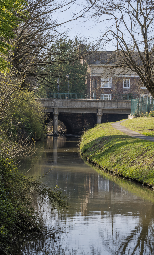
That road crossed the Gaywood River beside the gate. Part of the bridge survives beneath the modern roadway. Historic England considers the first bridge to have been built in the early fourteenth century, while its surviving stone arches date from the early sixteenth. Traffic still follows a route used when the town was Bishop’s Lynn.
The alternative name, St Catherine’s Gate, came from a chapel or hermitage dedicated to the saint which stood outside the town, on the north side of the road. Pilgrims travelling towards Walsingham probably used this entrance, although the records do not identify particular pilgrims who passed through it.
A place of defence and control
A medieval town gate controlled people, goods, and information. It was a defensive structure, a workplace, and a point at which the borough could enforce its regulations.
Accounts for 1340–41 record £8 5s 8½d spent on timber for the East Gates. Three years earlier, a springal had been installed there. This mechanical weapon used twisted ropes or sinews to fire heavy bolts. The expenditure shows that the gate was expected to withstand attack rather than serve merely as an impressive entrance.
The Corporation appointed a gatekeeper or porter. His oath required him to open and close the gate at the proper times, attend the mayor, assist the town watch, and report misconduct. In 1436, the keeper received a substantial club to prevent people entering “at undue seasons”.
The East Gate was probably Lynn’s busiest landward entrance. In 1653, its porter received £1 15s a year, compared with £1 5s paid to the South Gate porter. Richards thought the difference reflected the greater volume of country traffic using the eastern road.
In 1541–42, shortly after Henry VIII took Lynn from the Bishop of Norwich, the gate underwent major work. The king’s arms were placed above its outward-facing arch, while the town’s arms appeared on the inner side. Travellers approaching from Gaywood were confronted by a statement in stone. They were entering the king’s borough, not the bishop’s.
The royal arms survived the gate. After spending part of the nineteenth century in an outhouse in Littleport Street, they eventually reached the courthouse in College Lane. They remain one of the few objects directly connected with the vanished building.
Soldiers at the gate
The East Gate recovered its military purpose during the Civil War. In October 1642, Lynn’s Corporation ordered drawbridges to be constructed at the East and South gates “with as much speed as may be”.
The precaution was tested in April 1643, when Sergeant-Major Livewell Sherwood approached from Norwich with about one hundred dragoons and demanded entry. Lynn’s mayor refused to raise the drawbridge or open the gate. Sherwood could not cross the water or overcome the adjoining defences, so he withdrew.
Lynn openly declared for Charles I later that summer. Parliamentary forces under the Earl of Manchester surrounded the town in August and bombarded it for about three weeks. After Lynn surrendered on 16 September, the East Gate became the scene of another confrontation.
Colonel Russell and his soldiers approached after dark. Lynn’s representatives claimed that the great doors could not be opened so late and proposed admitting the Parliamentarians one at a time through the narrow wicket. A hostile crowd gathered inside, a gunner was ordered to fire, and the agreement nearly collapsed. Russell’s men were eventually admitted and marched along the Damgate, now Littleport Street, towards the Tuesday Market Place.
The episode gives us a rare glimpse of the gate in use. It had a drawbridge, large doors, and a smaller opening through which only one person could pass. A gateway built to regulate travellers briefly reduced an army to single file.
Flood, plague, and ordinary life
The gate also stood at the centre of quieter emergencies. During outbreaks of plague, Lynn’s entrances could be closed or closely watched. The same gateways that sustained trade became barriers intended to keep infection outside.
In 1671, floodwater covered the eastern approaches so deeply that boats could reportedly be rowed from the East Gate towards Gaywood. Haycocks floated away across the surrounding land. The account places the gate in its physical setting: beside the Gaywood River, on the edge of a low-lying town whose roads were vulnerable to flooding.
Most days were less dramatic. Carts, animals, travellers, market produce, and merchandise converged at the gate. The porter opened the doors, watched those entering, and closed them again at night. That ordinary traffic eventually brought about the gate’s destruction.
Catherine the Great and the inconvenient paintings
The Walpole collection was sold to Catherine the Great in 1779 for about £40,500. No modern conversion adequately conveys the value of the transaction because comparisons based on prices, wages, land, or social status produce very different results. It was an immense sum for one of Britain’s leading private art collections.
The paintings were packed at Houghton Hall and transported to Russia. Lynn was the nearest major port, so a journey through the town is geographically plausible. Several pictures required large cases and careful handling.
No carrier’s account, harbour entry, packing list, letter, or newspaper report yet found confirms that the collection passed through the East Gate. Nor does any known document record a case becoming stuck beneath its arch. Richards described the obstruction and the later demolition without mentioning the paintings.
A less dramatic version of the story may still be true. The cases might have been unloaded, carried through the gateway, and returned to their wagons. Such an incident would have exposed the limitations of the arch, but it could not have caused its immediate demolition. The structure survived until 1800.
The paintings belong to local tradition. The high-loaded wagons belong to the documented history.
When the road outgrew the gate
By the late eighteenth century, traffic on the eastern road was increasing. Parliament had authorised improvements to routes from the East Gate towards Gayton, Grimston, Hillington, and Dersingham. Larger wagons and better roads brought greater pressure upon the medieval entrance.
In May 1792, the Corporation decided to take down an arch on the eastern side of the gate. The precise nature of this alteration remains uncertain, but it appears to have been an attempt to ease the obstruction while preserving the main structure. It failed. In July 1800, the Corporation ordered the whole gate to be removed.
William Richards explained the decision in his History of Lynn, published in 1812:
“They had been for sometime a subject of complaint on account of the difficulty of entrance for highloaded waggons, by reason of the lowness of the arch.”
Richards regretted the loss of a building with a “somewhat venerable appearance”, but accepted that its removal had become necessary. His account is the strongest surviving explanation because he lived in Lynn and wrote only twelve years after the event.
The demolition formed part of a wider change taking place in English towns. Medieval gates which had once provided security were becoming obstacles to commerce. Lynn’s East Gate had been designed for packhorses, livestock, carts, and smaller wagons. By 1800, it could no longer accommodate the traffic using one of the town’s principal roads.
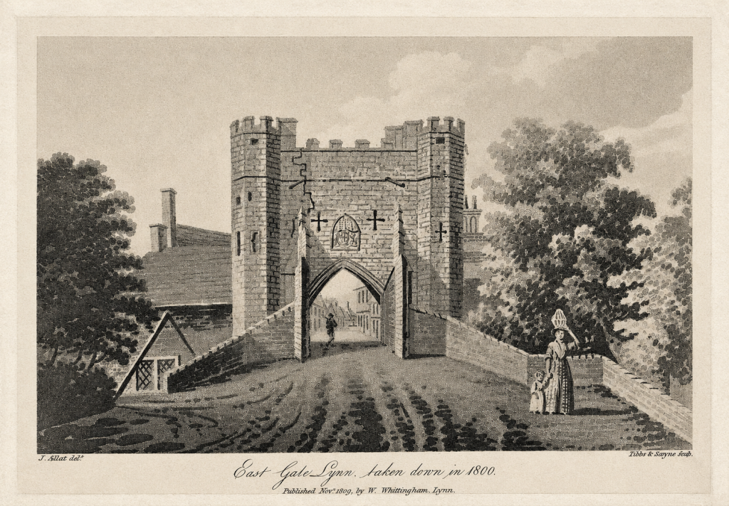
James Sillett’s aquatint, East Gate Lynn, taken down in 1800, was published in 1809. It must have been based on an earlier drawing, another image, or local recollection, but it preserves the clearest view of the lost gateway. The picture shows a tall central arch flanked by rounded towers, with adjoining walls and the road narrowing as it entered the town.
What survived
A tradition claims that stone from the demolished gate was taken to Hillington and reused in the southern entrance to Hillington Hall. The gateway there was designed by William John Donthorne around 1830, thirty years after the East Gate disappeared. Reused masonry could have been incorporated into the building, but Historic England’s listing does not identify any stone from Lynn. Without estate accounts or building bills, the story remains unproved.
The surviving river bridge offers firmer evidence. Its upper structure has been altered, but early sixteenth-century stone arches remain beneath Gaywood Road. The gateway disappeared because it obstructed traffic, while the crossing continued to carry the road.
This bridge should not be confused with Dodman’s Bridge, a short distance farther west. Dodman’s Bridge was built in 1869–70 to carry Gaywood Road over the new railway branch to Alexandra Dock. Before the railway cutting was excavated, no bridge was required at that spot. The medieval crossing is the Bridge at East Gate.
Today, nothing above ground marks the place where a porter once stopped travellers and soldiers waited outside the wicket. The royal arms survive in College Lane, while the bridge remains hidden beneath the road.
Catherine the Great’s paintings may have passed this way. What finally defeated the East Gate, however, was the ordinary wagon.
© James Rye 2026
Book a Guided Tour with a Trained and Qualified King’s Lynn Guide Through Historic Lynn
References
- Art UK. “Unknown Artist, Henry VIII’s Coat of Arms.” King’s Lynn Crown Court, College Lane. Accessed 14 August 2026. https://artuk.org/discover/artworks/henry-viiis-coat-of-arms-312764
- Flintham, David. “King’s Lynn under Siege: How a Small Field in North Lynn Illuminated Civil War Fortress Engineering.” Current Archaeology, 6 April 2023. https://the-past.com/feature/kings-lynn-under-siege-how-a-small-field-in-north-lynn-illuminated-civil-war-fortress-engineering/
- Folger Shakespeare Library. “An Act for Repairing and Widening the Roads from the East Gate of the Town of King’s Lynn.” 1791. https://catalog.folger.edu/record/814108
- Hillen, Henry J. History of the Borough of King’s Lynn. 2 vols. Norwich: East of England Newspaper Company, 1907. https://archive.org/details/historyofborough01hill
- Historic England. “Bridge at East Gate, Gaywood Road.” National Heritage List for England, entry 1291272. https://historicengland.org.uk/listing/the-list/list-entry/1291272
- Historic England. “Gateway and Lodges Approximately 150 Metres South of Hillington Hall.” National Heritage List for England, entry 1077613. https://historicengland.org.uk/listing/the-list/list-entry/1077613
- Historic England Research Records. “East Gate.” Heritage Gateway, HOB UID 879532. https://www.heritagegateway.org.uk/Gateway/Results_Single.aspx?resourceID=19191&uid=879532
- Norfolk Historic Environment Service. “Site of East Gate, King’s Lynn.” Norfolk Heritage Explorer, NHER MNF72097. https://www.heritage.norfolk.gov.uk/record-details?MNF72097=
- Richards, William. The History of Lynn. Vol. 2. Lynn: W. G. Whittingham, 1812. https://www.gutenberg.org/files/62372/62372-h/62372-h.htm
- Sillett, James. East Gate Lynn, Taken Down in 1800. Aquatint published by W. Whittingham, 1809. https://commons.wikimedia.org/wiki/File:Sillett_-_East_Gate_Lynn,_taken_down_in_1800.jpg