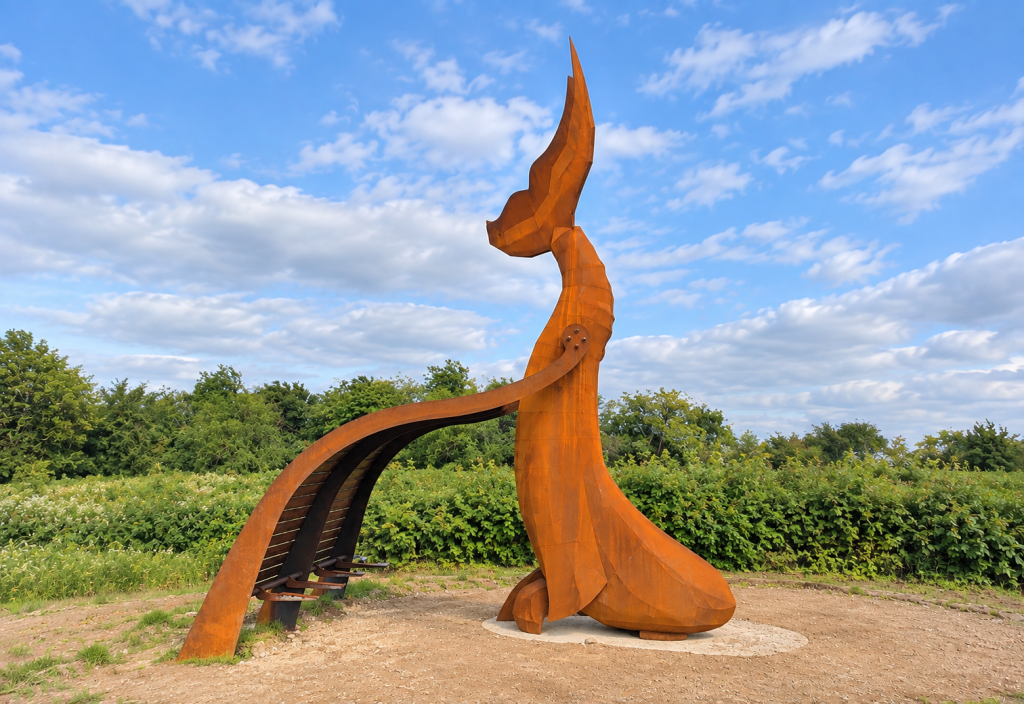
Why does a giant whale stand beside the River Nar at the southern entrance to King’s Lynn?
The answer lies beneath the grass. Harding’s Pits may now appear to be a surviving patch of countryside, but the ground contains filled clay workings, brickfield debris, railway ash, dredged river material, domestic refuse, and industrial waste. During its long history, the land has been used by brickmakers, allotment holders, travelling showmen, courting couples, children, council refuse workers, wildlife volunteers, and campaigners fighting a supermarket development.
The whale is only the most visible part of a much stranger story.
A triangle created by river and railway
Harding’s Pits occupies low-lying ground close to the meeting of the Great Ouse and the Nar. The medieval Carmelite friary known as Whitefriars stood immediately to the north, between All Saints’ Church and the river. It was founded in about 1260 and surrendered in 1538. Its surviving fifteenth-century gateway still marks the northern approach to the Pits. Older residents sometimes called the ground “the Abbey”, although the Carmelites were friars rather than monks, and the precise extent of their property remains uncertain.
The familiar triangular shape of Harding’s Pits is much more recent. The realignment of the Great Ouse, completed in 1821, helped establish its western boundary. A railway branch to the South Quay, opened in 1849, enclosed it on the eastern side. South Lynn then spread around it as houses, railway facilities, the gasworks, fertiliser manufacture, engineering works, and other industries occupied the southern approaches to the town.
Harding’s Pits was therefore not an ancient field that escaped change. It was a piece of land shaped by some of the largest engineering projects in nineteenth-century Lynn.
The pits appear
The Borough Council’s environmental research identifies the site as a brickfield in the middle of the nineteenth century. Clay was dug from the ground, leaving excavations which filled with water when extraction ended. The demand was easily understood. Lynn was expanding, and its new houses, factories, warehouses, railway structures, and yards required an enormous quantity of bricks.
It is possible that bricks were fired on the site. Local research suggests that more than one kiln operated in South Lynn and that one may have stood at Harding’s Pits. The clay workings are securely documented; the precise locations of the kilns are less certain. No dependable evidence has yet been found for the lime kilns sometimes associated with the site.
The flooded holes eventually became the defining feature of the landscape and gave the Pits their name. They survived into the twentieth century, surrounded by allotments, scrub, rough paths, and open ground.
Who was Harding?
The most likely namesake was William Derisley Harding, a Victorian engineer, manufacturer, farmer, and drainage official.
Harding manufactured and repaired steam engines in Lynn in partnership with Joseph Turner until their business was dissolved in 1858. He later served as engineer to the Bedford Level Corporation, superintendent of the Great Ouse Outfall Board, and a Commissioner of Sewers. His work placed him at the centre of the continuing struggle to maintain the embankments, pumps, locks, drains, and outfalls of the Fens.
In 1850, Harding bought reclaimed land from the Eau Brink Commissioners. He built Islington Lodge and established a substantial agricultural property on which he raised pigs and grew potatoes and wheat. The house was reportedly constructed with bricks handmade on the estate, and the remains of the kilns were visible many years later.
Everything seems to fit. Harding owned land in the right district, had an interest in engineering and drainage, and possessed both the means and the opportunity to extract clay for brickmaking.
One link is still missing. No surviving deed, estate plan, rate-book entry, or contemporary advertisement has yet been found which states that William Derisley Harding owned the particular excavations known as Harding’s Pits. He remains the convincing candidate, rather than the conclusively proven namesake.
A playground with real dangers
Once industrial digging declined, local people began using the land informally. Children played beside the water, allotment holders cultivated nearby plots, and couples found privacy among the rough vegetation. The site was neglected in an official sense, but it was never unused.
The flooded pits could be dangerous. Cecil Gawthorpe, a young boy, was found drowned in one of them in 1928. He was buried in Hardwick Road Cemetery. In 2019, members of the Gawthorpe and Heaton families planted an oak tree on the Green in his memory.
Local tradition also holds that horses requisitioned for military service during the First World War were grazed here before being taken away by train. Its position beside the railway makes the story possible, although a military record or contemporary newspaper report has not yet been located. It should be treated as remembered history rather than established fact.
Filling the holes with Lynn’s rubbish
Disused clay pits provided an obvious place to dispose of unwanted material.
Informal tipping from nearby industries probably began in the later nineteenth century and continued until about 1928. The deposited material included domestic refuse, fire-grate ash, demolition rubble, and industrial waste. During the 1950s and early 1960s, King’s Lynn Municipal Borough Council used Harding’s Pits as an official rubbish tip.
When tipping ended, the land was covered with soil and left as rough open ground. Modern investigations have revealed “made ground”, meaning soil mixed with material deposited by human activity, with an average thickness of about three metres. In some places, it extends to more than five metres. Parts of the northern area were also covered with dredged material and a relatively thin layer of topsoil.
The clay pits did not disappear through natural silting. They were progressively filled with the remains of the town.
Travelling showmen associated with Lynn Mart later used part of the rough ground as winter quarters. A local midwife remembered attending families there and delivering several babies. Their presence became part of the site’s community history and later inspired some of its public sculpture.
Is Harding’s Pits contaminated?
Its history as a brickfield, industrial dumping ground, railway margin, and municipal tip inevitably raised questions about the safety of the soil.
Several investigations were undertaken between 1988 and 2017. Particular attention was paid to arsenic and lead in the surface soil and to the possibility that these substances might be absorbed by the abundant blackberry bushes. Tests in 2009 found comparatively low levels in both shallow soil and blackberry fruit. The assessment found no significant risk to recreational users, volunteers maintaining the site, or people eating the berries.
In 2017, the Borough Council concluded that there was no evidence of harm, or of a significant possibility of significant harm, under the site’s existing use. Harding’s Pits was therefore not classified as contaminated land under Part 2A of the Environmental Protection Act 1990.
That does not mean that the ground is untouched or free from buried waste. It means that its present use as open recreational land does not meet the legal threshold for designation as contaminated land.
Further engineering work took place in 2010, when a large surface-water storage area was excavated to assist drainage and flood protection for the Nar Ouse regeneration area. Suspected hotspots were removed or controlled, unsuitable excavated material was taken away, and a protective capping system was installed. The Borough Council and Environment Agency subsequently approved the work.

The supermarket that never arrived
By the 1990s, Harding’s Pits had become vulnerable to development. A proposal emerged to build a supermarket on the site.
To a developer, the ground may have appeared to be poorly maintained former industrial land close to the town centre. Local residents saw it differently. They had used it for walking, play, informal recreation, wildlife watching, and access between South Lynn and the historic town.
A pressure group called King’s Lynn 2000 was formed to oppose the proposal. Its members spent several years trying to have the land registered as a village green. The Borough Council, which owned the ground, resisted that application, although the supermarket scheme was eventually abandoned.
The campaign established an idea which has guided the site ever since: Harding’s Pits was not empty land waiting for a proper use. Its roughness, openness, and informal character were themselves valuable.
Creating a wild green
In 2003, the Borough Council approached former members of King’s Lynn 2000 after learning that Countryside Agency grants were available for community open spaces. The Harding’s Pits Community Association was formed and incorporated as a not-for-profit company in 2004.
Residents were clear about what they did not want. Harding’s Pits was not to become a manicured municipal park with formal flower beds and tightly controlled vegetation. Their plan retained bramble thickets and rough habitats while adding paths, meadow areas, seating, and new trees.
On one Saturday in December 2004, volunteers planted more than 400 trees. The work was supported by a £100,000 Countryside Agency grant, and the Association entered into a 25-year agreement to manage the land. Volunteers have continued to mow paths, clear litter, maintain trees, protect wildlife habitat, and keep the site accessible.
Why a whale?
The great wooden whale became the best-known symbol of the new Doorstep Green.
Created by Suffolk artist Ben Platts-Mills and his assistants, it was installed in 2006. The five-metre structure, carved from large oak timbers, weighed about three and a half tonnes. It was designed as both a sculpture and a shelter, with an enormous tail rising above a place where visitors could sit and meet.
Before beginning the sculptures, Platts-Mills worked with pupils from Whitefriars, Greyfriars, and St Michael’s primary schools. Their suggestions helped create an eccentric collection which included fishermen, tumblers, wildlife, and a seal carrying a submarine on the end of its nose. The tumblers recalled the travelling showmen who once wintered on the ground.
The whale referred to Lynn’s Arctic whaling trade and to the Greenland Fishery building in nearby Bridge Street. At least nine Lynn ships are believed to have participated in whaling voyages between 1774 and 1821. Their catches returned to the Nar, where blubber was rendered into oil for lighting, soapmaking, and lubrication.
The sculpture quickly became more than an historical reference. It was a meeting place, a recognisable landmark on the southern approach to Lynn, and a feature marked on local maps. It was particularly popular with younger visitors.
The whale returns in steel
Sixteen years of wind, rain, and decay eventually weakened the wooden structure. Its tail had to be removed for safety, while deterioration elsewhere made repeated repairs increasingly impractical. The Harding’s Pits Community Association decided that a metal replacement would preserve the whale’s role as a shelter and landmark while providing a much longer life.
The proposed project cost approximately £30,000. The Association committed £3,500 from its own funds, while £26,500 was awarded through the Borough Council’s Community Infrastructure Levy programme. The budget included removal of the old sculpture, fabrication of the replacement, delivery, installation, VAT, and a contingency allowance. More than 120 local residents supported the application.
The old whale was removed by April 2024. Its successor was designed and fabricated by Able Engineering Limited of King’s Lynn and installed at the end of May. Made from Corten, or weathering, steel, the new structure develops a protective rust-coloured surface. Its curving ribs and elevated tail recall the wooden whale without attempting to copy it exactly.
Borough Mayor Paul Bland formally opened the steel whale on 15 June 2024, during celebrations marking the twentieth anniversary of the Doorstep Green. Alderman Paul Richards spoke about Lynn’s maritime and industrial history, while the Community Association explained that the sculpture commemorated the whaling trade but also celebrated living whales as symbols of the natural world.
A new interpretation panel was unveiled at the same ceremony. King’s Lynn Town Guides helped fund it, ensuring that visitors could understand why a whale had appeared beside the Nar.
The replacement is a particularly appropriate addition to Harding’s Pits. A local engineering company used an industrial material to recreate a community landmark on land once dominated by brickmaking, railway activity, and heavy industry.
Wildlife growing above waste
Harding’s Pits now contains woodland, scrub, brambles, grassland, meadow, and damp areas. The Community Association has recorded more than 100 bird species, nearly 200 plant species, and a range of mammals, reptiles, amphibians, and invertebrates.
Its wildlife value developed partly because the ground was left rough for so long. The mixture of disturbed soils, wet hollows, railway margins, dense scrub, and open grass created a variety of habitats within a small area.
The present Green is therefore neither ancient wilderness nor a disguised landfill. It is a new landscape that has grown from the interaction of industrial disturbance, natural recolonisation, careful engineering, and sustained voluntary work.
Ten acres and a possible village green
The public space was enlarged in 2025. Approximately half a hectare of land to the north, previously allocated for housing, was added to the Green. A further 0.3 hectares at the south-eastern corner became a community orchard, bringing the total open space to about four hectares, or ten acres.
The northern extension includes a circle of seven oak trees connected with Ackroyd and Harvey’s Beuys Acorns project. The trees were grown from acorns gathered from Joseph Beuys’s 7000 Oaks, an environmental artwork begun in Kassel in 1982. The Lynn planting linked Harding’s Pits with an international project concerned with urban renewal and the relationship between communities and nature.
The long campaign for stronger protection has also been revived. The proposed village green now includes the Doorstep Green, the community orchard, and the Beuys oak site. In June 2026, the Borough Council reported that the application was still under consideration.
© James Rye 2026
Book a Walk with a Trained and Qualified King’s Lynn Guide
References
- Art UK. “The Whale.” 2006.
- Borough Council of King’s Lynn and West Norfolk. CIL Spending Panel Report. 29 August 2023.
- Borough Council of King’s Lynn and West Norfolk. Contaminated Land Inspection Report: Hardings Pits. Revised November 2017.
- Borough Council of King’s Lynn and West Norfolk. Designation of a Village Green: South Lynn. January 2024.
- Borough Council of King’s Lynn and West Norfolk. Infrastructure Funding Statements, 2023–24 and 2024–25.
- Harding’s Pits Community Association. “About Harding’s Pits.”
- Harding’s Pits Community Association. “Hardings Pits Is Expanding!” 1 March 2025.
- Harding’s Pits Community Association. “Why the Whale?”
- Harding’s Pits Community Association. “William Derisley Harding.”
- KL Magazine. “Memories of Lynn’s Whaling History.”
- Norfolk Historic Environment Record. “Site of Carmelite Friary, Whitefriars.”
- Radio West Norfolk. “New Sculpture Unveiled.” June 2024.