Photo © James Rye 2023
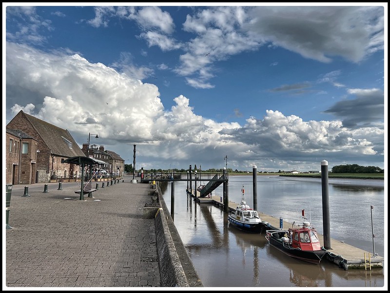
Stand on King’s Lynn’s quayside and the Great Ouse seems permanent. The town faces it, streets lead towards it, and for centuries ships have entered Lynn through its broad tidal channel. It is difficult to imagine the town without the river, yet the Great Ouse has not always flowed through King’s Lynn. Before it took its modern course in the thirteenth century, another river appears to have occupied much of its place. That river was the Little Ouse.
Even more surprisingly, recent archaeological research suggests that the Little Ouse may itself have been deliberately diverted towards Lynn around 1100, at about the time Bishop Herbert de Losinga was establishing the medieval town. The familiar story of Lynn growing beside a conveniently placed river may therefore have things the wrong way round. The river may have been brought to Lynn.
Before the Great Ouse
Around AD 1000, the southern shore of the Wash looked very different from today. Saltmarsh, mudflats, tidal creeks, and river channels occupied a broad landscape in which the boundary between land and water continually shifted.
Before the Great Ouse reached Lynn in the thirteenth century, the town stood beside a network of smaller rivers, tidal creeks, and estuarine channels. The principal north-flowing watercourse south of the town was the Wiggenhall Ee, or Water of Wiggenhall, while the Nar approached from the south-east and the Gaywood from the east. Within Lynn, natural waterways later known as the Millfleet, Purfleet, and Fisherfleet helped to shape the developing settlement. These waters entered a broad tidal haven beside the town. The Great Ouse did not arrive in an empty landscape: it captured and greatly enlarged an existing river system.
At about the beginning of the twelfth century, Herbert de Losinga, Bishop of Norwich, began developing a new settlement at Lynn. He founded St Margaret’s Church, encouraged the growth of the town, and helped establish the foundations of the borough which became Bishop’s Lynn. Recent research by the archaeologist Kenneth Penn suggests that Herbert’s ambitions may have extended far beyond founding a church and promoting a settlement. In a study published in 2022, Penn argues that the Little Ouse, which had previously flowed towards the Wisbech system, was deliberately diverted northwards towards Lynn at about this time. His reconstruction brings together medieval documents, archaeological evidence, aerial photography, LiDAR, and radiocarbon dating.
If Penn’s interpretation is correct, this was an extraordinary piece of medieval engineering. Bringing the Little Ouse towards Lynn gave the developing town a navigable connection with the Fenland waterways and the prosperous agricultural country beyond them. In the opposite direction lay the Wash, the North Sea, and the ports of England and continental Europe. Lynn could become the meeting place between inland river traffic and seagoing ships. Herbert may therefore have done much more than choose a favourable place for a new town. The church, settlement, harbour, and river connection may have formed parts of a single ambitious enterprise.
Lynn’s forgotten river
For perhaps a century or more, the principal substantial river passing Lynn was therefore the Little Ouse rather than the Great Ouse. We should not imagine it as simply a smaller version of the river we see today. Medieval Lynn stood within a much broader watery landscape where rivers, tidal creeks, marshes, and artificial channels met and changed course. The Nar approached from the south, the Gaywood River entered from the east, and the tides of the Wash reached deep into the estuary. Floods and silting altered channels naturally, while people embanked marshes, dug drainage channels, blocked waterways, and reclaimed land.
The town grew within this landscape rather than simply alongside it. Water penetrated deep into Lynn. The Millfleet entered from the south, the Purfleet reached into the commercial centre, and the Fisher Fleet was associated with the Gaywood River farther north. Boats could come surprisingly far into the settlement, bringing goods close to houses, workshops, warehouses, and markets. Something of this geography survives in the shape of historic Lynn. The old town developed as a long, relatively narrow settlement between the waterfront and firmer ground to the east. King Street ran broadly parallel with the river, while streets and lanes led westwards towards quays and landing places. The fleets cut through this pattern and helped determine where people built. Water was not simply something that flowed past medieval Lynn. It ran into the town and helped give it its shape.
By the thirteenth century, Lynn was already becoming a major commercial centre. Then the geography of the Fens changed again.
When the Great Ouse came to Lynn
Older histories sometimes give the impression that the Great Ouse was suddenly diverted to Lynn in 1236. The precise date at which the Great Ouse was diverted towards Lynn remains uncertain. Sir William Dugdale, writing in the seventeenth century from earlier records and manuscripts, believed that the change occurred during the reign of Henry III, between 1216 and 1272. A later tradition assigns the event specifically to November 1236, following severe flooding around Littleport, but no royal grant of that year authorising the diversion has yet been identified. The crucial change appears to have been the opening or enlargement of a channel between Littleport Chair and Rebeck, near Brandon Creek, allowing the Great Ouse to enter the Little Ouse system and flow northwards towards Lynn. By 1292–93 the diversion had certainly occurred, since a royal commission was reportedly considering restoring waters towards their former Wisbech outfall.
The work was probably pursued by a combination of major landowners, especially the Bishop of Ely and local monastic interests, with support from the burgesses of Lynn, whose borough charter of 1204 had already encouraged commercial ambition.
The real process was probably much less tidy. Medieval Fenland waterways were continually affected by floods, silting, embankments, dams, drainage works, and deliberate cuts. Altering one channel could redirect water many miles away, and changes which began as local attempts at drainage or flood control could have consequences across a much larger area.
During the thirteenth century, the Great Ouse increasingly abandoned its older connection towards Wisbech and flowed northwards towards Lynn. It did not, however, have to cut an entirely new river from the Fens to the Wash. A route was already there. The Little Ouse had apparently been flowing towards Lynn for more than a century, and the Great Ouse entered this existing system. With its much greater volume of water, it eventually became the dominant river and transformed the channel into something approaching the Great Ouse we recognise today. The distinction is easily missed. The Great Ouse did not arrive at a riverless Lynn and create its waterfront. It took over an existing river route.
The consequences for Lynn were profound. The town now stood at the maritime entrance to one of eastern England’s greatest river systems. In an age when transporting heavy goods over poor roads was difficult and expensive, navigable waterways provided a remarkably efficient means of moving large cargoes. Lynn was connected inland through the Ouse system while the Wash gave access to the North Sea. Ships brought wine, timber, fish, salt, cloth, and other goods into the port, while agricultural produce from Lynn’s extensive hinterland travelled in the opposite direction. In later centuries, coal from north-eastern England became one of the great commodities entering Lynn and moving onwards into the interior. The town was simultaneously a seaport and a river port, standing where two transport networks met.
The transformation also affected Wisbech. Before the change, the Great Ouse had been connected with waterways running towards the Wisbech estuary, including the Wellstream or Well Creek system. The reorganisation of the Fenland rivers therefore altered the commercial geography of both towns. Lynn gained direct access to the much larger Great Ouse drainage basin and, by the later Middle Ages, had become one of England’s leading provincial ports.
The rivers beneath modern Lynn
The Little Ouse was only one part of this story. The Nar had its own changing lower course through the marshland south of Lynn, while the Gaywood River entered the watery landscape farther north and was associated with the Fisher Fleet. Smaller creeks and channels appeared, disappeared, silted up, or were incorporated into drainage systems. Centuries of reclamation make the old landscape difficult to imagine because roads, buildings, embankments, and drainage channels have imposed firm boundaries upon places where land and water were once much less easily separated.
Kenneth Penn’s research therefore adds a remarkable possibility to the familiar story of Lynn’s foundation. Herbert de Losinga has long been associated with the establishment of medieval Bishop’s Lynn and the foundation of St Margaret’s Church. If the diversion of the Little Ouse formed part of the same enterprise, his project was considerably more ambitious than founding a settlement beside the Wash. Somewhere in the Fenland around 1100, labourers dug, widened, dammed, or connected waterways through an exceptionally difficult wet landscape. Their names have disappeared, and we cannot reconstruct every stage of their work, but the result may have been a navigable Little Ouse flowing northwards towards Herbert’s developing town.
A century or more later, the Great Ouse followed the same route. The larger river eventually overwhelmed the identity of the smaller one, and the Little Ouse largely disappeared from Lynn’s story. Today we stand on South Quay, look across the Great Ouse, and see a landscape which appears entirely natural. In reality, the river before us is the result of centuries of floods, silting, drainage, reclamation, and human engineering.
The Great Ouse has not always belonged to Lynn. Before it came, another river was here.
And that river was the Little Ouse.
© James Rye 2026
Book a Guided Tour with a Trained and Qualified King’s Lynn Guide Through Historic Lynn
References
- Maddock, Helen. “Livelihoods and Liberties of Low Countries Immigrants in Late Medieval Lynn.” History(2025).
- Penn, Kenneth. “The Diversion of the Little Ouse: Herbert de Losinga and the Founding of Bishop’s Lynn.” Proceedings of the Cambridge Antiquarian Society 111 (2022): 179–190.
- Historic England. Historical and archaeological records relating to medieval King’s Lynn and its waterways.
- Oxford Archaeology. Archaeological investigations concerning the early landscape and waterways around King’s Lynn.