
Photo © James Rye 2022
In December 2009, archaeologists digging beneath a former dairy depot in Austin Street, King’s Lynn, encountered a problem that would have been familiar to the town’s medieval inhabitants. Water began pouring into their excavation. Even with a pump running, they struggled to keep the trench dry. Eventually, they had to use hand augers to investigate the lowest deposits.
What they uncovered was a reminder that much of medieval Lynn had been built on ground that was anything but secure. Beneath the modern surface lay thick layers of clay and silt, evidence of land that had once been marshy and repeatedly affected by water. Above them were deposits of soil, rubbish, broken pottery, and building materials, apparently tipped there over several centuries to raise the ground.
The discoveries feature in a new study by Katerina Velentza, Hannah Worthen, and Briony McDonagh, published in the International Journal of Historical Archaeology on 6 November 2026. Their research examines how people across medieval and early modern England coped with flooding, using archaeological evidence that has often been overlooked.
For Lynn, a town built beside a tidal river and surrounded by low-lying land, the study raises some interesting questions. How much of the medieval settlement was vulnerable to flooding? What did its inhabitants do about the danger? And how far did their efforts to control water influence the way the town developed?
A town built on uncertain ground
Medieval Lynn owed its existence to water. The Great Ouse provided access to the Wash and the North Sea, allowing merchants to trade with ports in England and continental Europe. Smaller waterways, known as fleets, served the town’s neighbourhoods and connected the river with inland areas.
But the advantages of such a location came at a price. The settlement developed among tidal creeks, marshes, and relatively elevated banks of natural sediment. Some land offered firm foundations for buildings and streets, while other areas remained wet or vulnerable to inundation.
During the twelfth century, Lynn expanded northwards beyond the Purfleet into the district known as the Newland. The enlargement of the settlement created valuable opportunities for trade and development, but it also brought occupation closer to marshy ground.
For many years, historians assumed that the Newland was reclaimed through a relatively organised programme of drainage and land raising. Archaeological discoveries have complicated that picture. Excavations undertaken during the redevelopment of the Vancouver Shopping Centre and the construction of the Clough Lane car park between 2003 and 2005 revealed that the process was much more gradual.
These investigations, covering approximately twelve per cent of the historic town centre, found little evidence of a single, systematic programme of reclamation during the thirteenth and fourteenth centuries. Instead, the ground had accumulated through natural processes and the repeated dumping of material. Occupation was concentrated towards the riverfront, with some inland areas remaining undeveloped for much longer.
The 2009 excavation in Austin Street provided a particularly revealing example of that uneven development.
What lay beneath Austin Street?
The archaeologists excavated a trench approximately four metres square, reaching a depth of about two metres before using augers to investigate lower deposits. The earliest layers, between roughly two and three metres beneath the present surface, contained clayey silts and sandy clays consistent with flooding or prolonged waterlogging.
One substantial layer of dark grey silt was about half a metre thick. It contained shells, animal bones, medieval pottery, and building fragments. Environmental samples also produced fish bones, fish scales, seeds, and traces of charred wheat. The mixture suggested that rubbish had either been discarded into the wet ground or carried there by water.
The investigators concluded that this part of the Newland had probably remained marshland or wasteland during much of the medieval period. It may occasionally have served as meadow, but there was little indication of permanent occupation on the excavated plot.
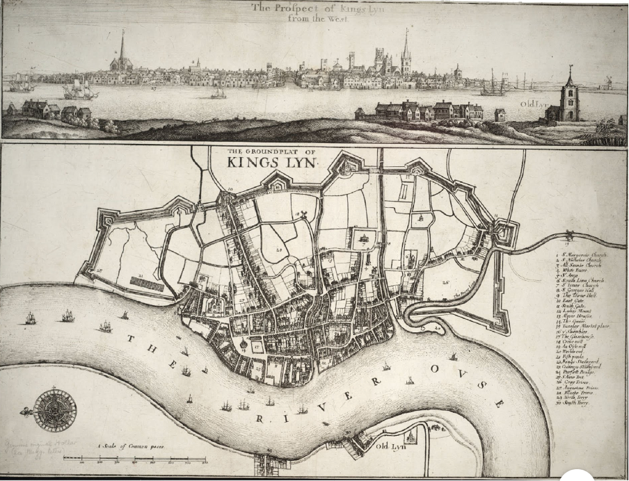
An early map helps explain why. Austin Street was once known as Hopmans Way, and a sixteenth-century map shows a fleet running near the western side of the excavation site, roughly along the line of modern Austin Fields. A bridge crossed the watercourse where it met the street. Another fleet ran farther south, between Austin Street and Norfolk Street, while a watermill stood to the east.
The thirteenth-century Survey of the Newland recorded properties along Hopmans Way, but those shown on the reconstructed map were west of the bridge. None appeared on the eastern side where the archaeological excavation took place.
It is tempting to imagine medieval householders keeping their distance from a particularly troublesome stretch of ground. The archaeology does not prove that flooding was the reason for the absence of houses, but it makes the possibility plausible.
The site eventually changed. From the fifteenth or sixteenth century onwards, and probably continuing into the early seventeenth century, large quantities of material were dumped over the earlier wet deposits. The rubbish included pottery, animal bones, broken bricks, and fragments of medieval roof and floor tiles. Some of the building materials may have come from the demolition of religious establishments following the Dissolution of the Monasteries, possibly including the nearby Austin Friary.
Among the more unusual objects was a fragment of a fitting from a medieval book. Its presence raises the intriguing possibility that some of the waste came from an ecclesiastical building, although the precise origin cannot be established.
The accumulated material gradually raised the surface and made it more suitable for occupation. A modest timber structure was subsequently erected, probably during the seventeenth or eighteenth century.
Whether the rubbish was deliberately deposited as part of a planned reclamation scheme is uncertain. The site may simply have provided a convenient place to dispose of waste. Whatever the intention, the result was to turn wet, marginal ground into land that could be put to further use.
The flood beneath Norfolk Street
Austin Street was not the only place where archaeologists encountered evidence of medieval flooding.
Investigations on land between Austin Street and Norfolk Street, subsequently occupied by the Lidl supermarket, revealed extensive alluvial deposits. The excavators interpreted these as the remains of a major flood, probably involving the Great Ouse and its associated fleets, sometime between approximately 1350 and 1500.
Below the flood deposits were earlier medieval layers, including dark organic silts and clay. Some deposits suggested ground that had been wet or waterlogged before the later inundation.
The Norfolk Street evidence differs from that at Austin Street. At the former, archaeologists proposed a single substantial flood event. At Austin Street, the deposits could represent repeated flooding or the gradual accumulation of sediment in a marshy environment.
Neither excavation allows the precise date of a flood to be established, nor can the water’s source be identified with certainty. Nevertheless, the discoveries suggest that parts of the Newland were exposed to significant flooding long after the area had become an established part of medieval Lynn.
The same Norfolk Street excavations produced evidence of workshops, including a smithy and a fish-hook manufacturing site. The presence of industry alongside waterlogged ground is a reminder that medieval townspeople did not necessarily avoid environmentally vulnerable places. Access to water, commercial routes, and established streets could make a location attractive despite the disadvantages.
A town that could not stop dumping its rubbish
Lynn’s surviving civic records reveal another difficulty. The town’s inhabitants were repeatedly throwing rubbish into the very waterways that served their businesses and helped drain their neighbourhoods.
The Hall Books contain numerous orders intended to stop the practice. During the early fifteenth century, the authorities issued four such orders within about twenty-five years. By 1450, the problem was sufficiently persistent for the corporation to impose a graduated series of penalties on anyone throwing filth into the fleets or harbour.
The first offence brought a fine of four pence, the second eight pence, and the third could result in imprisonment.
These were not insignificant penalties, especially for poorer inhabitants. The repeated orders also suggest that earlier attempts at enforcement had achieved limited success.
The waterways gradually changed their function. Some of the fleets that had once provided access for small vessels became drainage channels or open sewers. Others were eventually filled in or covered over. By the later eighteenth century, the fleet west of the Austin Street excavation had disappeared from the maps.
There was a contradiction in the town’s treatment of water. Keeping channels open was necessary for drainage and navigation, but the low-lying ground beside them was an obvious place to dispose of waste. Dumping rubbish might gradually raise land that was otherwise difficult to use, while simultaneously obstructing the movement of water.
Lynn’s inhabitants were altering the environment around them, sometimes with consequences that the town authorities struggled to control.
The disastrous flood of January 1338
The dangers of living beside the Wash were not confined to the town itself. Across the river, the fertile lands of Marshland depended on a network of embankments and drainage channels to protect fields and settlements from the sea.
On 12 and 13 January 1338, severe flooding struck the region.
Research by the archaeologist Peter James Brown, drawing on the Close Rolls of Edward III and other medieval records, identifies inundation at Tilney, Walpole, Walsoken, West Walton, and Emneth on 12 January. Wiggenhall and Terrington were flooded the following day.
The surviving documents describe serious damage to agricultural land, property, and flood defences. Sea banks required extensive repairs, while flooded fields produced little or no income. The affected communities petitioned for relief from taxation because of the losses they had suffered.
Some later descriptions of the disaster became exaggerated or confused. The suggestion that destruction at Walpole was caused by a tidal wave originating from an Icelandic volcanic eruption, for example, has no reliable supporting evidence. The documentary record nevertheless establishes that the flooding was widespread and economically damaging.
The damage reached beyond individual farms. Land that could no longer produce crops reduced the resources available to local communities, and the cost of repairing embankments placed additional demands on landowners. Where several settlements depended on the same protective banks, failures in one place could threaten neighbouring communities.
There is no reliable evidence connecting the 1338 flood directly with the deposits discovered at Austin Street or Norfolk Street. The archaeological dating is insufficiently precise. The event does, however, demonstrate the scale of the flooding to which the lower Great Ouse and the surrounding Fens were exposed.
Who kept the sea out?
The people of medieval Marshland had developed a remarkably organised system for protecting their land long before the disaster of 1338.
Records of a Commission of Sewers for Wiggenhall, covering the years 1319 to 1324, survive in a published edition prepared by A. E. B. Owen. They offer an unusually detailed account of the obligations placed upon the inhabitants of a vulnerable agricultural community.
The word sewer did not then have its modern, predominantly sanitary meaning. It referred to channels and structures used to manage water, including drains and ditches.
Landowners whose property benefited from protective embankments were expected to contribute towards their maintenance. Some obligations were attached directly to the ownership of particular plots. A land grant from the early thirteenth century, for example, required the recipient to maintain specified lengths of sea bank and drain.
Communal labour was organised through a system known as menework. When repairs were required, those with an obligation to contribute could be summoned to undertake them. The Wiggenhall records prescribed a fine of four pence for failing to attend ordinary maintenance work, with a higher penalty of six pence for neglecting a summons connected with an urgent breach in a bank.
Officials known as dike reeves supervised the arrangements. Wiggenhall elected two such officers annually during the 1320s. They were responsible for organising work and administering the finances involved. The larger embankments and drainage channels, including the Pokedike, required cooperation between several Marshland communities.
Such arrangements demanded constant negotiation. A farmer whose land stood immediately behind a sea bank might see the need for repairs rather differently from someone whose property lay farther inland. Disagreements could arise about the amount of labour required, the distribution of costs, or the failure of a neighbour to carry out an obligation.
Yet no individual landowner could adequately protect an entire low-lying district. The maintenance of the defences depended upon collective action, backed by rules and penalties.
Lynn’s merchants were connected to this vulnerable landscape through the movement of agricultural produce and other goods. A serious flood in Marshland threatened not only the people living on the affected land, but also the economic activity of the wider region.
How other English towns managed flooding
The new study by Velentza, Worthen, and McDonagh examines evidence from towns and settlements across England between approximately 1200 and 1700. Rather than concentrating entirely on famous disasters, the authors investigate what archaeological deposits and surviving structures reveal about ordinary responses to flooding.
At New Romney in Kent, thirteenth-century storms left substantial deposits of sand and damaged buildings. Archaeological excavations identified evidence of structures undermined by moving water. Some locations were abandoned rather than rebuilt.
At Shrewsbury, inhabitants used streets and property boundaries to direct surface water towards drainage channels. Elsewhere, excavations have revealed embankments, timber revetments, and sluices intended to control the movement of water or protect vulnerable ground.
The researchers also draw attention to areas where periodic flooding was tolerated. Meadows beside rivers could benefit from the fertile sediment deposited by seasonal inundation. Not every flood was regarded as a disaster, provided that water reached places where its presence was expected and manageable.
For Lynn, the most useful comparison may be Hull.
Like Lynn, Hull developed as a medieval port beside a tidal estuary, occupying a landscape whose commercial advantages were inseparable from the dangers of water. Research published in 2024 by Briony McDonagh and her colleagues describes how Hull’s inhabitants managed flood risk through civic regulation and arrangements involving landowners and neighbouring communities.
Responsibility was shared, but not always willingly. In the winter of 1646–47, severe flooding in Hull and Holderness led to prolonged inundation and disputes about the cost of repairing defences. The problems were familiar ones: who should pay, whose land should be protected, and how far responsibility extended beyond an individual’s property.
The comparison suggests that Lynn’s experience was part of a wider history of English estuarine towns, where prosperity depended on water but demanded an almost continual effort to manage it.
What else is buried beneath Lynn?
The 2026 study makes a persuasive case for bringing archaeological evidence into modern discussions of flood risk. Layers of silt and sand can reveal places where water once caused damage. Repeated repairs to embankments may identify areas of persistent vulnerability, while the remains of abandoned buildings can show how communities responded when their protective measures failed.
Such evidence needs careful interpretation. A medieval flood deposit cannot tell us exactly what will happen during a future storm, particularly when river channels, sea levels, and drainage arrangements have changed so much. Nevertheless, it adds a historical dimension that modern flood records cannot supply.
For Lynn, the possibilities extend well beyond the discoveries already made.
The King’s Lynn Urban Archaeological Database, completed in 2022, has assembled information from numerous excavations and historic records. Further research could establish whether apparently separate flood deposits represent the same events, identify additional areas of former marshland, and trace the gradual disappearance of the town’s fleets.
There is also an opportunity to connect archaeological findings more closely with the town’s written records. The Borough Archives contain material relating to property ownership, public works, and the regulation of waterways. These could reveal how decisions about drainage and land reclamation were made, as well as the disputes that resulted.
One particularly interesting collection is held far from Norfolk. The Huntington Library in California possesses a manuscript volume compiled around 1660 containing copies of orders issued by the Norfolk Commissioners of Sewers between approximately 1601 and 1638. Its catalogue describes documents relating to the management of fens, marshes, and waterways around King’s Lynn. Detailed examination of those orders might reveal how responsibilities for maintaining drainage infrastructure were organised during the early seventeenth century.
The archaeological evidence also changes how we might picture the medieval town. Lynn was not simply a collection of quays, merchants’ houses, and churches standing beside a conveniently navigable river. It included stretches of wet and marginal ground, small streams that crossed its streets, and neighbourhoods where the level of the land was gradually raised by generations of inhabitants.
The ground beneath Austin Street preserves a particularly revealing part of that history. In 2009, the archaeologists struggled to keep their trench dry, much as the town’s earlier inhabitants had struggled to manage the water around them. What emerged from the mud was not evidence of one spectacular catastrophe, but a quieter history of gradual change, improvised solutions, and persistent vulnerability.
© James Rye 2026
Book a Walk with a Trained and Qualified King’s Lynn Guide
References
- Brown, Peter James. 2019. Weathering a Medieval Climate: Gauging the Impact of Natural Hazards on Northern European Society through Archaeology and History, AD 1000–1550. PhD thesis, Durham University. https://etheses.dur.ac.uk/13194/
- Clarke, Rachel, with contributions by Sue Anderson, Nina Crummy, Chris Faine, Carole Fletcher, Rachel Fosberry, and Helen Stocks. 2010. Medieval Flood Deposits, a Post-Medieval Structure and Post-Medieval Ground Levelling at the Former Dairy Depot, Austin Street, King’s Lynn. Oxford Archaeology East Report No. 1153. https://eprints.oxfordarchaeology.com/973/1/Report1153LR.pdf
- Hoggett, Richard, and Alice Cattermole. 2022. King’s Lynn Urban Archaeological Database: Project Report. Historic England Project No. 7656. https://www.west-norfolk.gov.uk/download/downloads/id/7178/kings_lynn_urban_archaeological_database_project_report_-_march_2022.pdf
- Huntington Library. Norfolk Commissioners of Sewers Manuscript Compendium. Manuscript HM 84000, compiled c.1660, containing orders dated c.1601–1638. https://www.huntington.org/collections/lib-msshm-84000
- McDonagh, Briony, Hannah Worthen, Stewart Mottram, and Stormm Buxton-Hill. 2024. “Living with Water and Flood in Medieval and Early Modern Hull.” Environment and History 30 (4): 585–614. https://doi.org/10.3828/whp.eh.63830915903577
- McDonagh, Briony, Hannah Worthen, and Stewart Mottram. 2025. “Governing Flood Risk in Mid Seventeenth-Century England.” Journal of Historical Geography 89: 13–26. https://doi.org/10.1016/j.jhg.2024.12.001
- Owen, A. E. B., ed. 1981. The Records of a Commission of Sewers for Wiggenhall, 1319–1324. Published with Dorothy M. Owen, ed., William Asshebourne’s Book. Norfolk Record Society, vol. 48. https://www.norfolkrecordsociety.org.uk/publications/
- Velentza, Katerina, Hannah Worthen, and Briony McDonagh. 2026. “Understanding the Archaeological Evidence of Flooding and Flood Risk Management for Medieval and Post-Medieval England.” International Journal of Historical Archaeology. Published online 6 November 2026. https://doi.org/10.1007/s10761-026-00836-7